Early Los Angeles City Views (1900 - 1925)
Historical Photos of Early Los Angeles |
 |
|
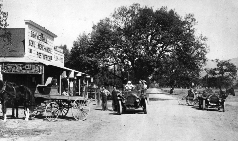
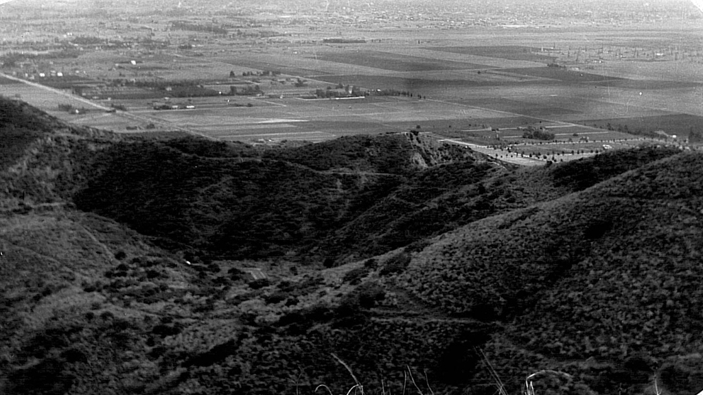
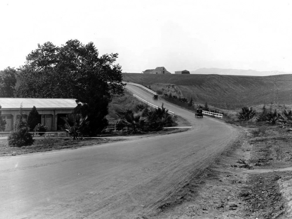
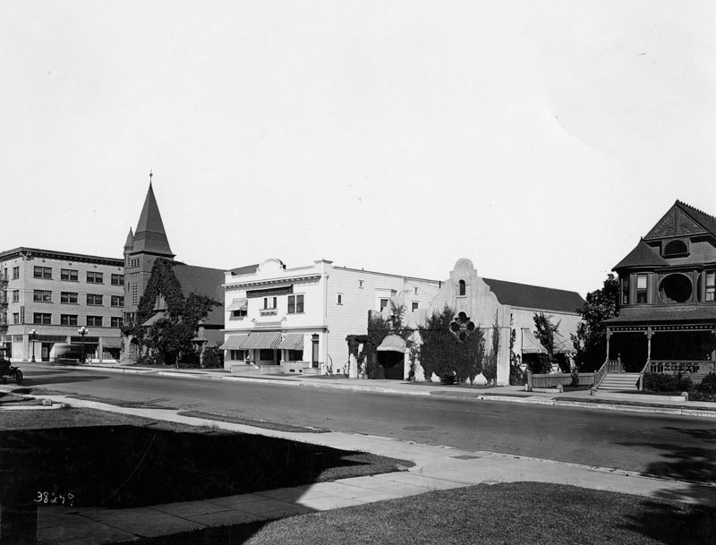
| (1911)^ - A view of the center of Chatsworth, now Topanga Canyon Boulevard looking north. On the left is Graves and Hill General Merchandise and Post Office. Horses and cars share the street. |
Historical Notes In the late 1800s the San Fernando Valley was divided into thirteen ranches, seven of which were located in the southern half of the valley and six in the northern half. The Granger Ranch, owned by Benjamin F. Porter, became Chatsworth Park. Chatsworth is located to the southeast of the Santa Susana Pass, an extremely steep mountain pass that stagecoaches had to traverse when travelling the Overland Stage Road from Los Angeles to San Francisco. Santa Susana became a relay station for the stagecoach lines where the drivers would trade in their tired horse before attempting to cross the Overland Stage Road. Being located near a relay station made Chatsworth an important town in term of transportation history in California. As late as 1891, Chatsworth remained an active relay station for the stagecoach lines.*##* |
 |
|
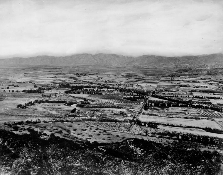
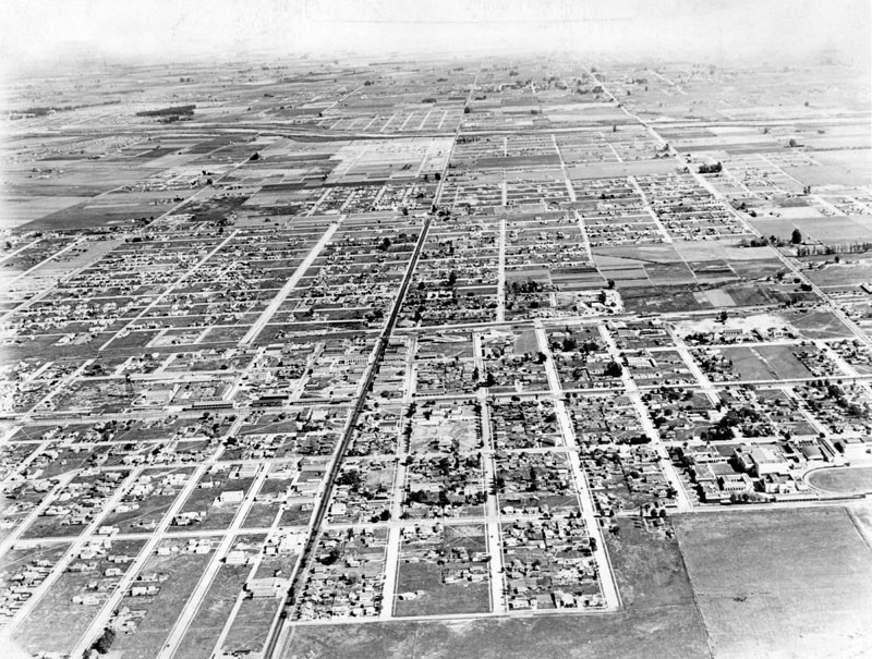
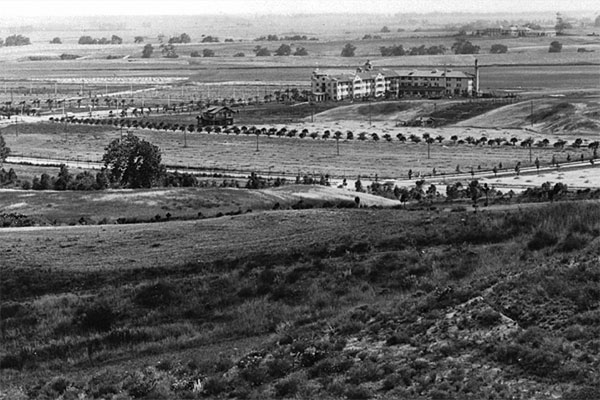
| (1910)^ - View looking north across the San Fernando Valley. Vast amounts of farmland can be seen throughout. Road on top left running diagonally is Lankershim. Road that comes straight down on the right is Vineland, which curves into Ventura Boulevard in the foreground. |
 |
|
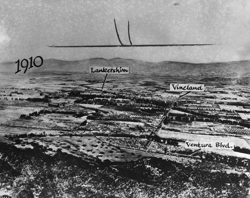
| (1910)^ - View of the San Fernando Valley in 1910 (Same as previous photo with street names annotated). |
Historical Notes As the City of Los Angeles authorized building 'William Mulholland's' Los Angeles Aqueduct from the Owens Valley to the city and valley, land speculation plans for the Los Angeles Farming and Milling Company property in the San Fernando Valley were developed. Construction began in 1905. Dryland farming could now be turned into crops, orchards and residential towns. In the "biggest land transaction ever recorded in Los Angeles County", a syndicate led by Harry Chandler, business manager of the Los Angeles Times, with Isaac Van Nuys, Hobart Johnstone Whitley, and James B. Lankershim acquired "Tract 1000", the remaining 47,500 acres of the southern half of the former Mission lands—everything west of the Lankershim town limits and south of the old furrow (present day Roscoe Boulevard) excluding Rancho Los Encinos and Rancho El Escorpión.*^ |
.jpg) |
|
| (1911)^ - Site of the future Van Nuys in 1911 looking north, showing work being done on Van Nuys Boulevard. Virginia Street (later Sylvan Ave.) is marked, behind which is an oil derrick. Tracks and a railcar are seen in the foreground. |
Historical Notes In anticipation of the Owens River Aqueduct and cheap water, Moses Hazeltine Sherman, H.J. Whitley, Harry Chandler and others began the great San Fernando Valley developmnet by buying out the Van Nuys-Lankershim land in 1910. The land was sub-divided and soon there would be a great land sale.*^ |
 |
|
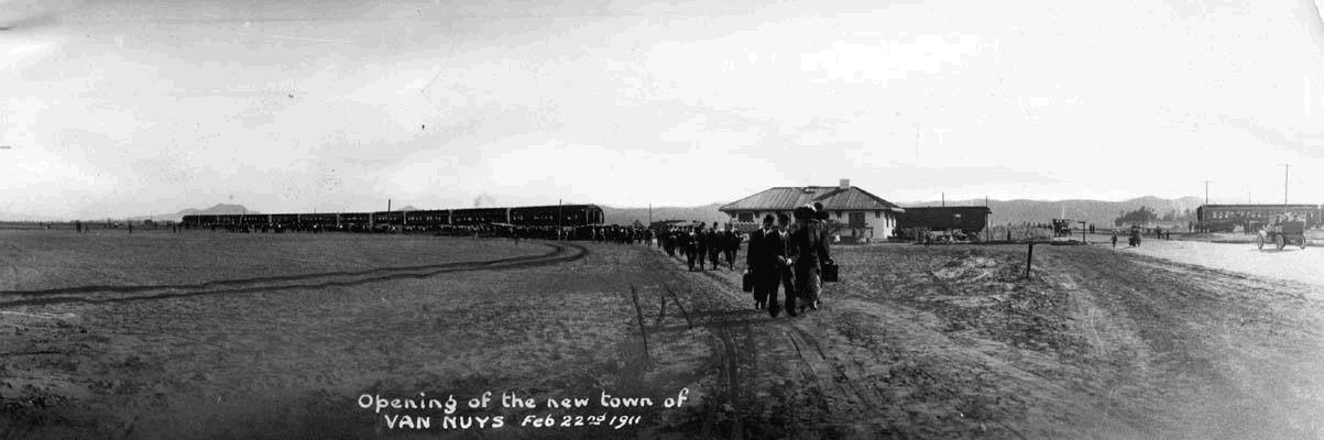
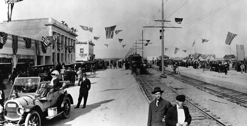
| (1911)^^^* - "Opening of the new town of Van Nuys" - February 22, 1911. This panoramic view shows a long procession of people walking away from the train depot toward the camera, some carrying luggage. A train unloading passengers is seen in the background. On the right, an early model car is seen heading toward a second train. |
Historical Notes On February 22, 1911, lot sales began. This sparked a population boom and marked the founding of Van Nuys.*^ |
 |
|
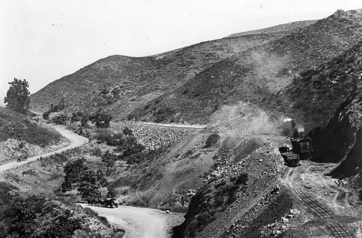
| (1911)^ - Tracks are being built through the hills of the Cahuenga Pass as shown on the right side of this picture. On the lower road can be seen supplies coming and going by teams of horses and wagons |
Historical Notes In 1911, General Sherman (as he was called) added an extraordinary streetcar line. Built over Cahuenga Pass, through North Hollywood to the 1911 town site of Van Nuys, and on to the 1912 town site Owensmouth, now Canoga Park.*^ |
 |
|
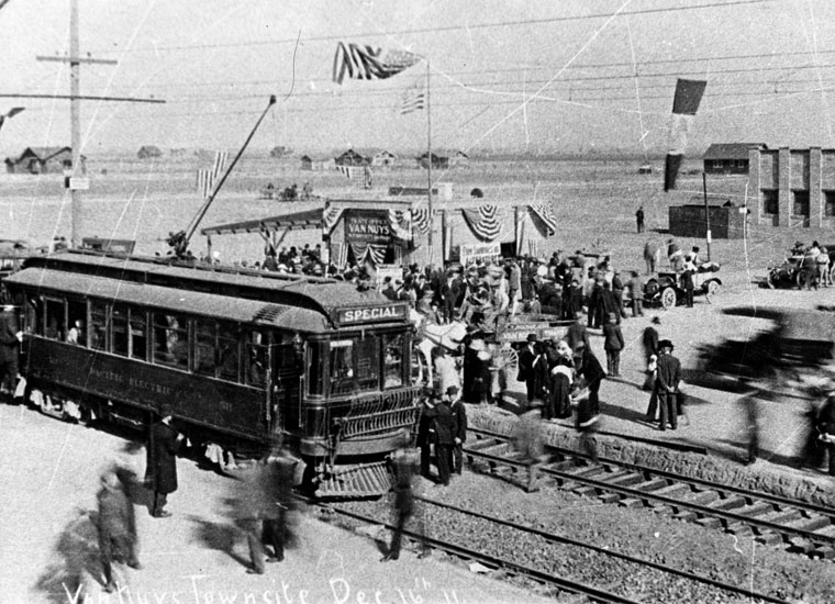
| (1911)^ - View of a crowd of people in Van Nuys waiting for the arrival of the first Pacific Electric "Red Car." American flags are drapped over lines that run over the tracks. |
Historical Notes The Hollywood-Van Nuys Extension was completed in December, 1911, and the first car entered Van Nuys on December 16, 1911.*^ |
 |
|
| (1911)^ - Crowds gathers to welcome the first street car to arrive in Van Nuys, December 16, 1911. |
Historical Notes Built over Cahuenga Pass, through North Hollywood to the 1911 town site of Van Nuys, and on to the 1912 town site Owensmouth, now Canoga Park, the streetcar line and the "$500,000 boulevard" named Sherman Way next to the tracks were the key to the development. By 1912, 45 minute streetcar service from Van Nuys to downtown and the "no speed limit" paved road (if you could get your "Model A" to do 30 mph) were key selling points. |
 |
|
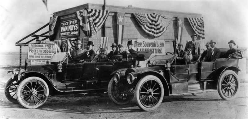
| (1912)^ - Opening of the first tract office in Van Nuys at North Sherman Way (later Van Nuys Boulevard) and Virginia Street (later Sylvan Street) in 1912, with two carfulls of eager salesmen waiting. W.P. Whitsett was the sales manager of the office. Lots started at $350. Electric car service and water from the Owens Valley entered the San Fernando Valley in 1913. Click HERE to see the Opening of the LA Aqueduct. |
Historical Notes Whitsett Avenue was named after William P. Whitsett who is remembered by some as the "Father of Van Nuys." He was a major land developer and water official in Los Angeles. The street was first known as Encino Avenue.^* |
 |
|
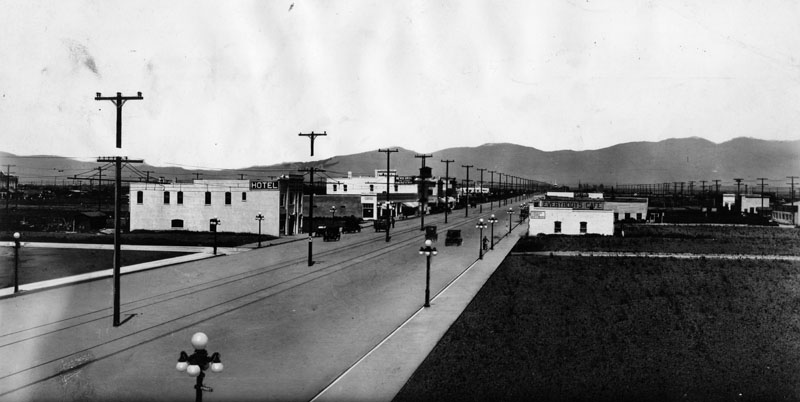
| (ca. 1912)^ - View of Van Nuys Boulevard, looking north, showing how Van Nuys was beginning to grow and flourish. (Note the ornate lamp posts along the sidewalks and the power lines situated in the center of the boulevard with tracks running on either side). |
Historical Notes The new Los Angeles Aqueduct changed the dynamics of growth in the San Fernando Valley. Land become more valuable and as a result towns began to grow and so did the number of farms. Valley farmers offered to buy the surplus aqueduct water, but the federal legislation that enabled the construction of the aqueduct prohibited Los Angeles from selling the water outside of the city limits. For the Valley communities, the choice was consent to annexation or do without. On March 29, 1915, by a vote of 681 to 25, residents of 108,732 acres of the San Fernando Valley (excluding Rancho El Escorpión and the communities of Owensmouth, Lankershim, Burbank and San Fernando) voted to be annexed by the City of Los Angeles. Owensmouth was annexed in 1917, West Lankershim in 1919, Chatsworth in 1920, and Lankershim in 1923. Small remote portions of the north and west Valley were annexed piecemeal even later: most of Rancho El Escorpión in 1958 and the remainder of Ben Porter's ranch as late as 1965. Burbank and San Fernando remain independent cities to this day.*^ Click HERE to see more in Construction of the LA Aqueduct. |
Click HERE to see more in Early Views of the San Fernando Valley |
* * * * * |
Downtown Los Angeles - 7th Street
 |
|
| (ca. 1912)^ - View looking toward the intersection of Olive and 7th Streets. The United States Hotel is at near left, and the Los Angeles Athletic Club building at 431 W. 7th Street is across Olive St. at the former site of the Hotel Baltimore. A few cars are seen and some retail shops are at right. |
 |
|
| (ca. 1912)^ - View looking east on 7th Street at Olive Street. The large building to the left is the Los Angeles Athletic Club. |
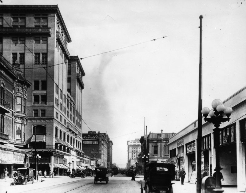
Historical Notes For decades, 7th Street was a thriving and busy shopping street, traversing all of the major named streets in Downtown. By the looks of this photograph, the same was true when this image was captured. Some of the businesses pictured here are, on the left: the Los Angeles Athletic Club, located at 431 West 7th Street, built by Parkinson & Bergstrom in 1911. This building was notable at the time for being the first in Southern California to have a swimming pool on an upper floor; Owl Drug Co., which became Owl Rexall Drugs in the 1940s; and the R.D. Bronson Desk Co., self-proclaimed as "The only exclusive dealers in Office Furniture in Los Angeles". And pictured on the right side: Southern California Wine Co.; and I.N. Van Nuys Building, designed in the Beaux Arts style by architects Morgan, Walls and Clements, and built by Scofield-Twaits Company in 1910-1911, the building is located on the southwest corner of Spring and 7th Street.^ |
 |
|
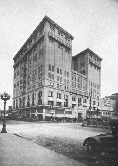
| (ca. 1912)*^^ - The Los Angeles Athletic Club located on the northeast corner of 7th and Olive at 431 West 7th Street. The Beaux Arts style building opened its doors in 1912. |
 |
|
| (ca. 1912)^ - View looking west on 7th St. at Hill. The L.A. Athletic Club is the large building on the right. In the foreground from the club appears a sign identifying the "Seventh and Hill St. Branch" of All Night and Day Dentist. |
 |
|
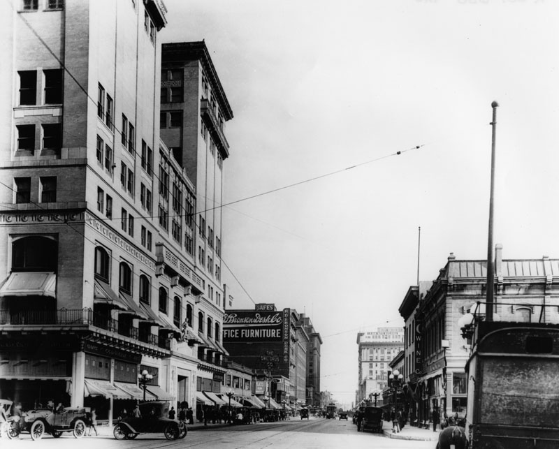
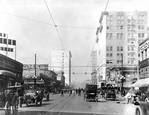
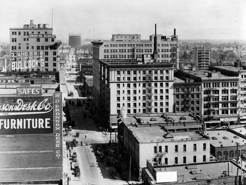
| (1913)^ - View of 7th Street, looking east from Hill Street. |
Historical Notes For decades, 7th Street was a thriving and busy shopping street, traversing all of the major named streets in Downtown. Some of the historical buildings pictured in this photograph are, on the left: Union Oil Building, built in 1922 by Curlett & Beelman; Bullock's, founded in 1907 by John G. Bullock; the R.D. Bronson Desk Co., self-proclaimed as "The only exclusive dealers in Office Furniture in Los Angeles". And pictured on the right side: the Hotel Lankershim, a large tripartite building erected in 1905 by one of Los Angeles' wealthiest and largest landholders in the state of California, Col. James B. Lankershim and designed by architect, Robert B. Young. The Hotel Lankershim, one of the last additions to the Los Angeles' hotel list and filled with everything that could in any way render it a perfect dwelling place, was yet another early 20th century landmark which is now gone, having been demolished after one of the earthquakes in the 1980s; and seen in the far distance on the right is Cooper, Coate & Casey Dry Goods Co., owned and operated for 38 years by Harry B. Coate.^ The above 300-foot tall gas holder or silo was located east of the Civic Center. It was built in 1912 by the LA Gas and Electric Co. and it's not clear when it was torn down. Shots of Downtown up through 1960 seem to show these structures in the background. In 1936 Los Angeles city voters approved a charter amendment authorizing the Bureau of Power and Light to issue revenue bonds in the amount of $46 million and purchase the electric system of Los Angeles Gas and Electric Corporation, the last remaining privately-owned system in LA. Click HERE to see more in Los Angeles Gas and Electric Co. |
* * * * * |
 |
|
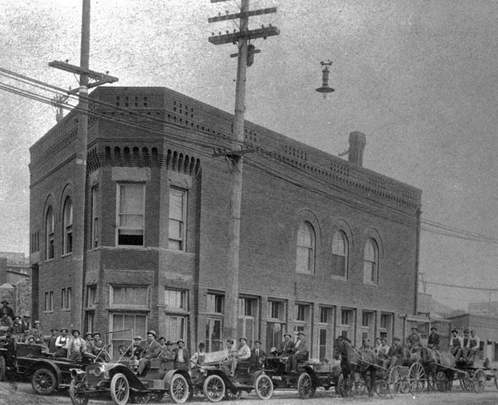
| (ca. 1912)* - Construction crews in cars and horse-drawn wagons in front of the City's first Water Department building located on the northwest corner of Marchessault and North Alameda streets (across from where Union Staion stands today). Click HERE to see more in Water Department's Original Office Building. |
Historical Notes In 1868, the City of Los Angeles approved a franchise water agreement on a 30 year lease basis with the private Los Angeles City Water Company. In 1899, after the end of the lease, a $2.09 million bond measure for the purchase of LA City Water Co.’s system was approved by city voters by a margin of nearly eight to one. After over two years of litigation the City of Los Angeles finally regained control of its water system on February 3, 1902. A new department was created called the Los Angeles Water Department. Click HERE to see a more detailed timeline in Water in Early Los Angeles. |
 |
|
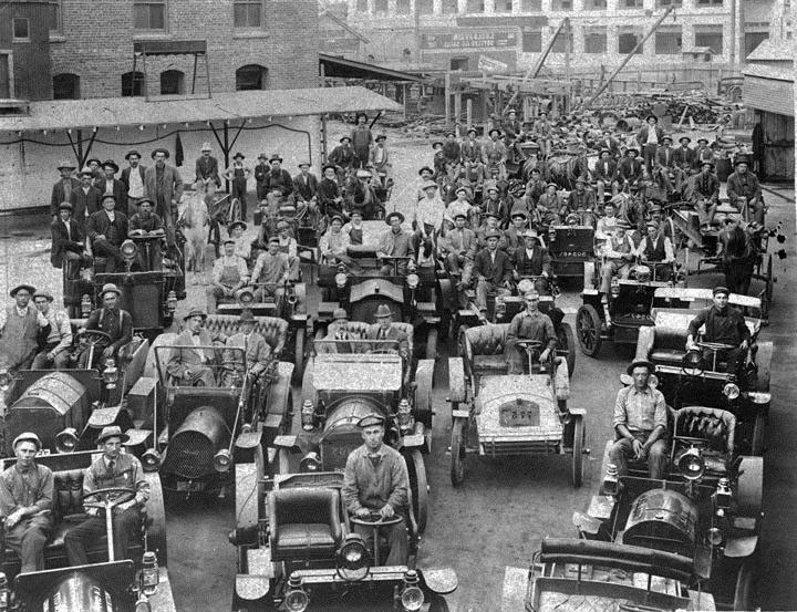
| (1912)* - Bureau of Water Works and Supply^ forces leaving Water Works Yard at 510 East Second Street (Second and Rose Streets). ^Click HERE to see Name Change Chronology of DWP. |
Historical Notes The man behind the wheel in the middle car of the second row is non other than William Mulholland. |
 |
|
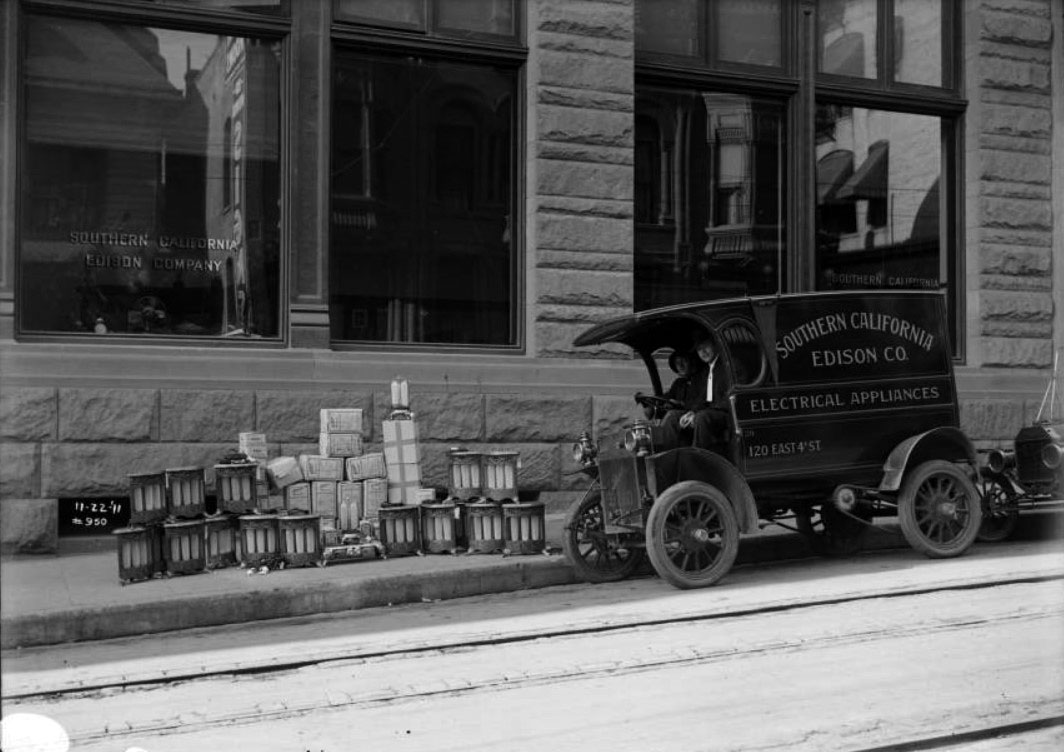
| (1911)*^#^ – View showing two men sitting in a "Buick" electric appliance delivery truck, #29, in front of the Fourth Street General Office Building of Southern California Edison Company. Various electric appliances are sitting on the curb. Address on the side of the truck reads: 120 East 4th Street, which is on the south side of 4th Street between Main and Los Angeles streets (the building still exists today). |
Historical Notes In 1911, there were three electric utilities serving the City of Los Angeles: Southern California Edison, Pacific Light and Power, and LA Gas and Electric Corporation. In 1916, the City formed its own municipal electric utility and called it Bureau of Power and Light. In 1937 the name changed to LA Department of Water and Power (DWP). By 1939 DWP became the sole electrical service provider for the City of Los Angeles. Click HERE to see more in First Electricity in Los Angeles. |
 |
|
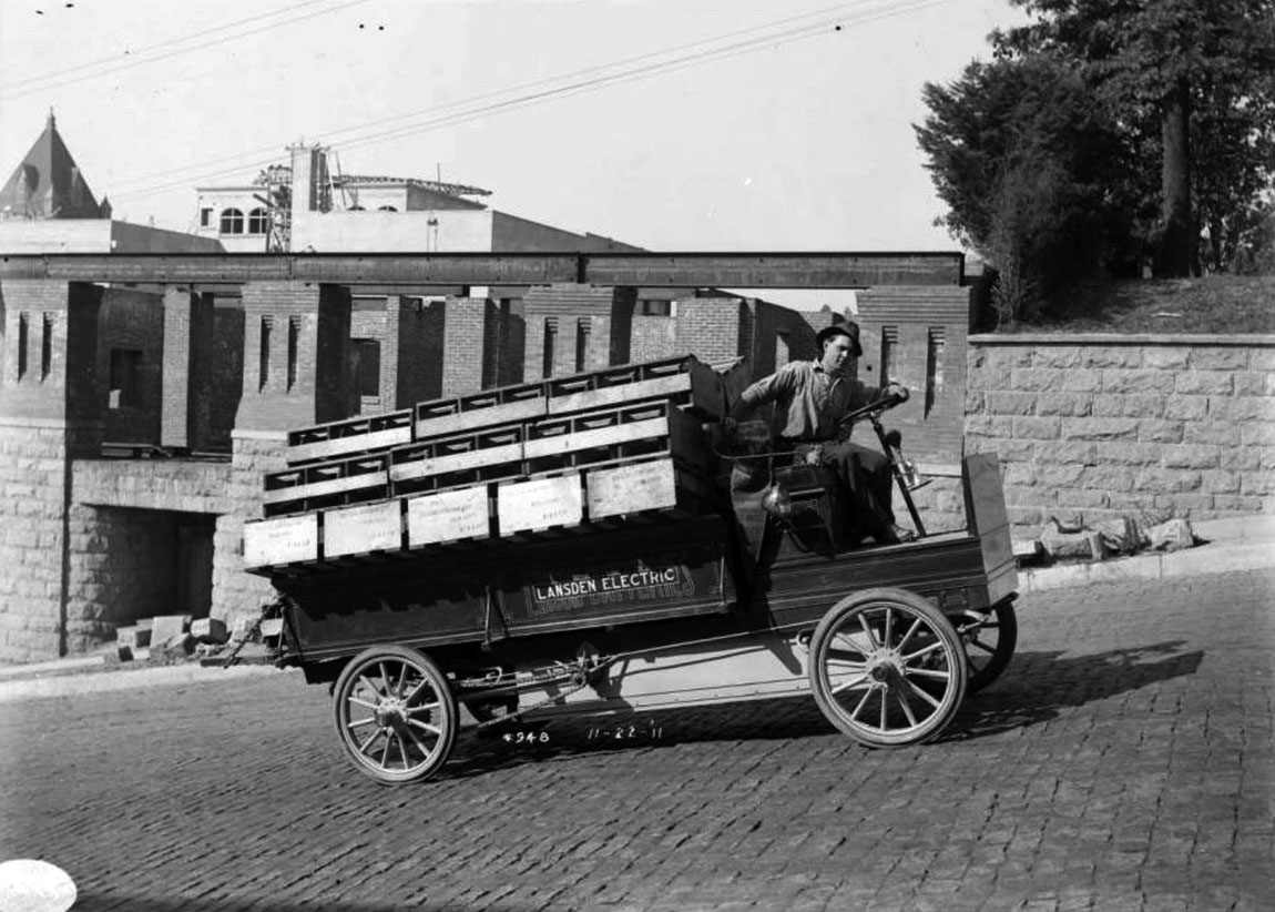
| (ca. 1912)*^#^ – View showing a Lansden Electric truck, operated by an Edison battery, on the 400 block of Grand Avenue. |
 |
|
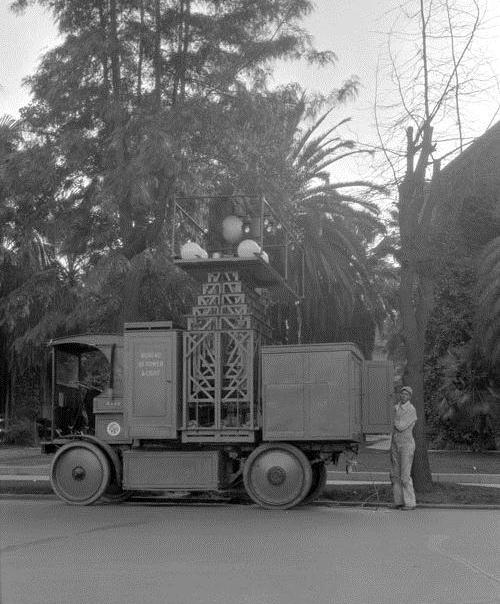
| (Early 1920s)* - An electric powered street light truck used by the Bureau of Power and Light. Click HERE to see more in Early Los Angeles Streetlights. |
* * * * * |
Compton
 |
|
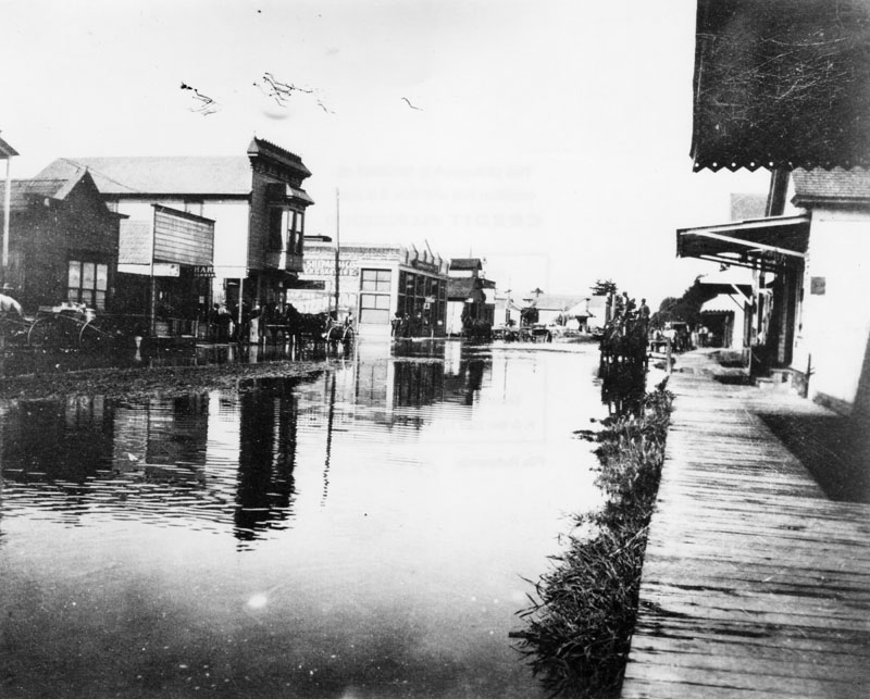
| (1903)^ - View of flooded streets in Compton, looking west on Compton Boulevard and north on Alameda. |
Historical Notes Because of its proximity to one of the main tributaries feeding into the Los Angeles River (Compton Creek), Compton and its surrounding area would periodically experience flooding especially during severe storms. Compton Creek drains a watershed of 42.1 square miles and is the last major tributary to enter the Los Angeles River before it reaches the Pacific Ocean.*^ |
 |
|
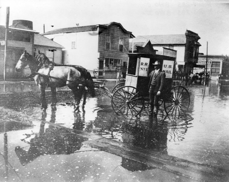
| (1903)^ - Flooded street looking west on Compton Boulevard from near Alameda Street A U. S. Mail coach drawn by horses is seen. |
Historical Notes Flooding in Compton was an all too often event until after the major storm of 1938 when cement-lined flood control channels were installed throughout Los Angeles County. |
 |
|
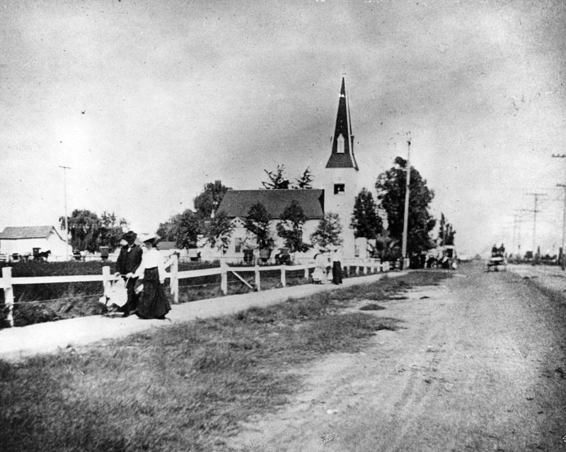
| (1905)^ - People stroll on a sidewalk that runs along the unpaved Willowgrove Avenue, north of Compton's City Hall. A church is seen in the center with a horse-drawn wagon in front. |
Historical Notes In 1867, Griffith Dickenson Compton led a group of thirty pioneers to the area. These families had traveled by wagon train south from Stockton, California in search of ways to earn a living other than in the rapid exhaustion of gold fields. Originally named Gibsonville, after one of the tract owners, it was later called Comptonville. However, to avoid confusion with the Comptonville located in Yuba County, the name was shortened to Compton. On May 11, 1888 the city of Compton was incorporated, it had a total population of 500 people. The first City Council meeting was held on May 14, 1888.*^ |
 |
|
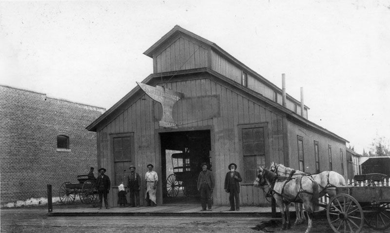
| (Early 1900s)^ - View showing the Compton Carriage Company. A horse drawn carriage is visible at right, and five men and a child stand near the entrance to the business. A carriage is visible just inside, and a man riding a carriage peers toward the camera from the side of the store, at left. |
 |
|
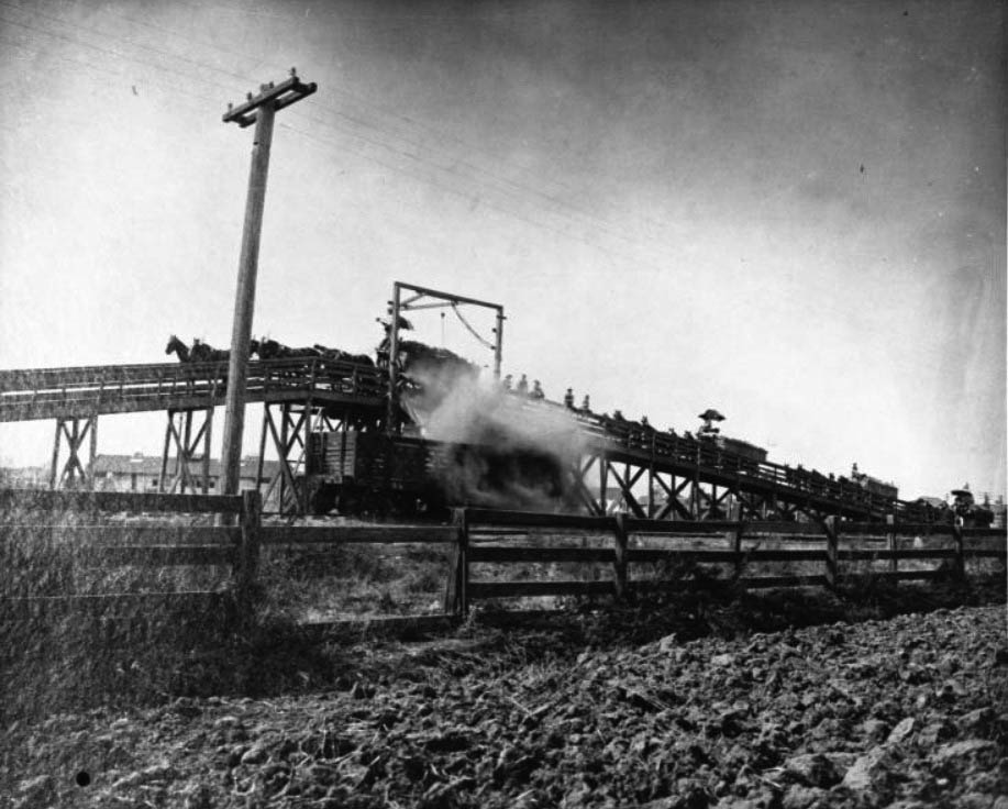
| (1910)^^ - View showing a beet dump on the Southern Pacific Line south of Myrrh Street parallel to Alameda Street. A long wooden trestle is pictured coming to a peak at left, where carts of sugar beets drawn by horse-and-carriage are being dumped into what appears to be a railroad car below. The train of carts extends the whole length of the trestle to the right. |
 |
|
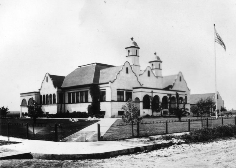
| (ca. 1912)^ - View showing the Mission Revival Style Compton High School. |
 |
|
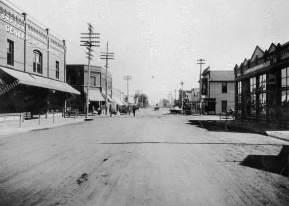
| (1914)^ - View looking East on Compton Boulevard at Tamarind Street. General stores and businesses can be seen on both side of the street. |
 |
|
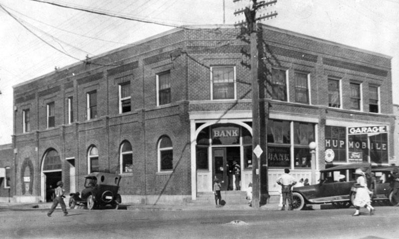
| (ca. 1910s)^ - Compton Bank at the southwest corner of Compton Boulevard and Tamarind Street. Pedestrians and automobiles can be seen at both left and right of the photo. |
 |
|
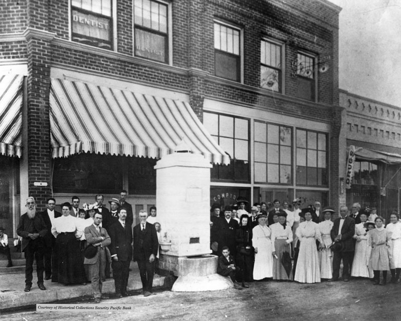
| (1912)^ - A crowd of men and women attend the dedication of a water fountain, at Compton Boulevard and Tamarind Street, in 1912. It stood in front of the present site (1992) of the Security-First National Bank. |
 |
|
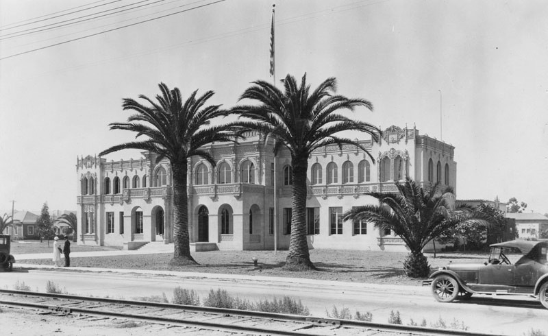
| (1926)^ - View showing Compton City Hall with palm trees in front. The ornate 2-story building has numerous arched windows and dentil molding all around. Two people stand along the sidewalk on the left, and part of a railroad track is visible at the lower forefront of the photo. |
Historical Notes Seven years after this photograph was taken, on March 10, 1933, a devastating 6.4 magnitude earthquake took lives, toppled schools, and caused major damage to the main business district - including the City Hall which was shaken into twisted ruin, and was eventually razed and re-built.^ |
 |
|
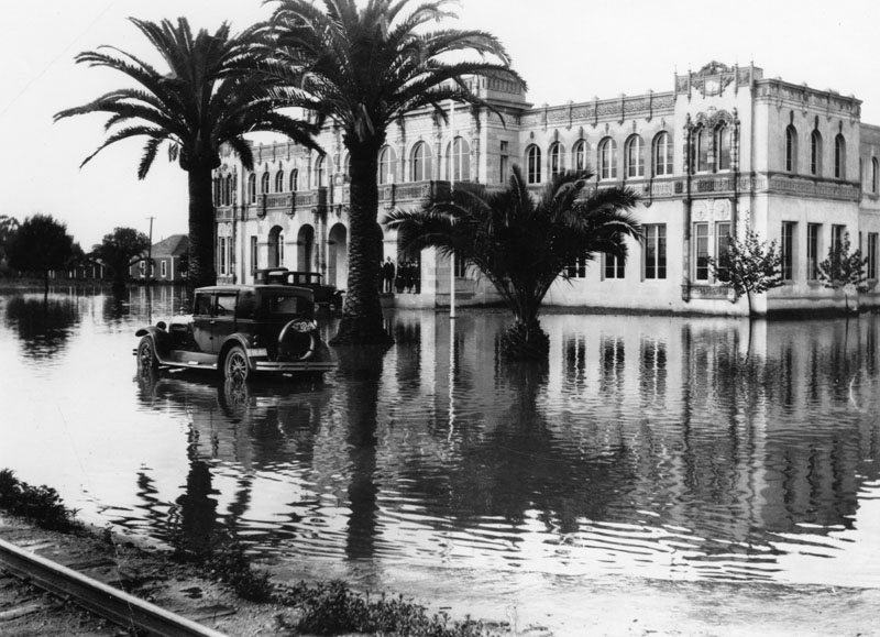
| (1928)^ - Exterior view of City Hall in Compton, framed by palm trees and surrounded by water. People can be seen standing near the entrance, perhaps wondering how they will get to their automobiles, the tires of which are partially submerged in water. Part of a railroad track is visible at the lower left of the photo. |
Historical Notes Flooding in Compton would continue until after the great floods of 1938. Between February 27th and March 3rd, 1938 Los Angeles was inundated with two storm systems delivering record breaking rainfalls. By March 3rd, the San Gabriel Mountains received 32 inches of rain, more than their average yearly total, and Los Angeles received over 10 inches of rainfall over the 5-day storm. 115 people lost their lives, thousands more were evacuated, over 6000 homes were damaged or destroyed, and 108,000 acres - one third of Los Angeles - was flooded. The San Fernando Valley, Venice, Compton, and Long Beach were the worst hit. The Los Angeles River was completely warped - new inlets were carved by the rushing water and the channels in areas shifted, nearly as much as a mile.**# |
 |
|
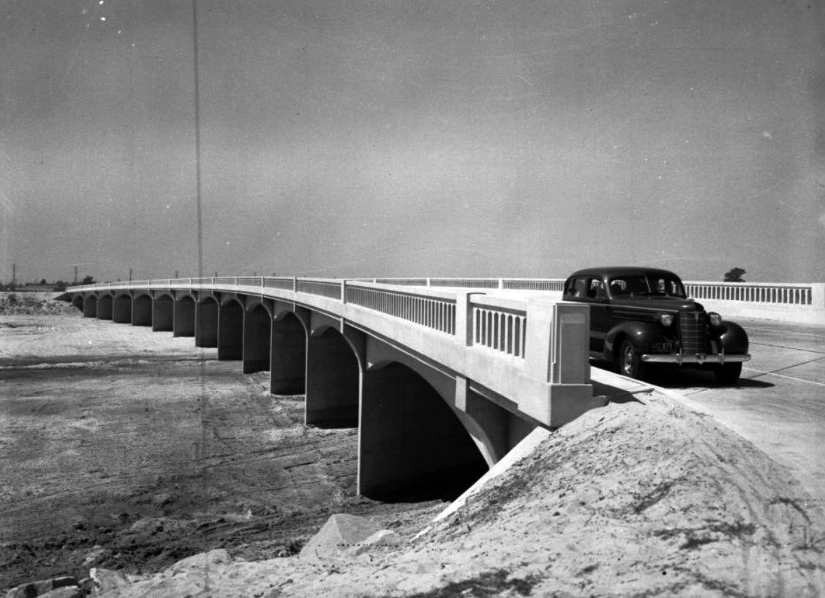
| (1937)^^ - View looking northwest showing the Atlantic Ave Bridge over the Los Angeles River in Compton. Click HERE to see contemporary view. |
Historical Notes Total channelization of the Los Angeles River began a few months after the 1938 floods. Since then, 278 miles of river and tributaries were retrofitted and more than 300 bridges were built. With the river encased in cement, the natural sharp turns were now straightened. Any evidence of vegetation was completely removed, allowing runoff from the San Gabriel Mountains to escape through the river and out of Long Beach at up to 45 miles-per-hour. Streets and sewers were connected to drains along the river, designed to quickly capture and move rainfall away from the surrounding streets.**# |
 |
|
| (1920)^ - Aerial view of the City of Compton looking east, showing the main intersection of Compton Boulevard and Alameda Street at center. |
Historical Notes 1920s: Voters approved adoption of a new municipal charter, which provided for the city manager form of government; Citizens celebrated opening of the Compton Airport; Compton Junior College was established; City administration moved to a new City Hall located at 600 N. Alameda Street. 1930s: On March 10, 1933, a devastating earthquake took lives, toppled schools and caused major damage to the main business district; The city began to shed the effects of the Great Depression of 1929, and the population increased.+^^ |
 |
|
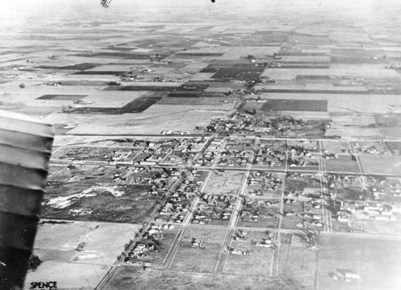
| (1930)^ – Aerial view of Compton looking east showing how much the city grew over a short 10 year period (see previous photo). |
Historical Notes 1940s: Like Americans everywhere, the Compton residents participated in civilian and military efforts during World War II. 1950s: The first African American families moved to the area; Centennial High School was built to accommodate a growing student population. 1960s: Voters elected Douglas Dollarhide, the City’s first African American mayor; Two African Americans and one Mexican American were elected to the school board.+^^ |
Click HERE to see more early views of Compton in the 1880s. |
* * * * * |
Beverly Hills
 |
|
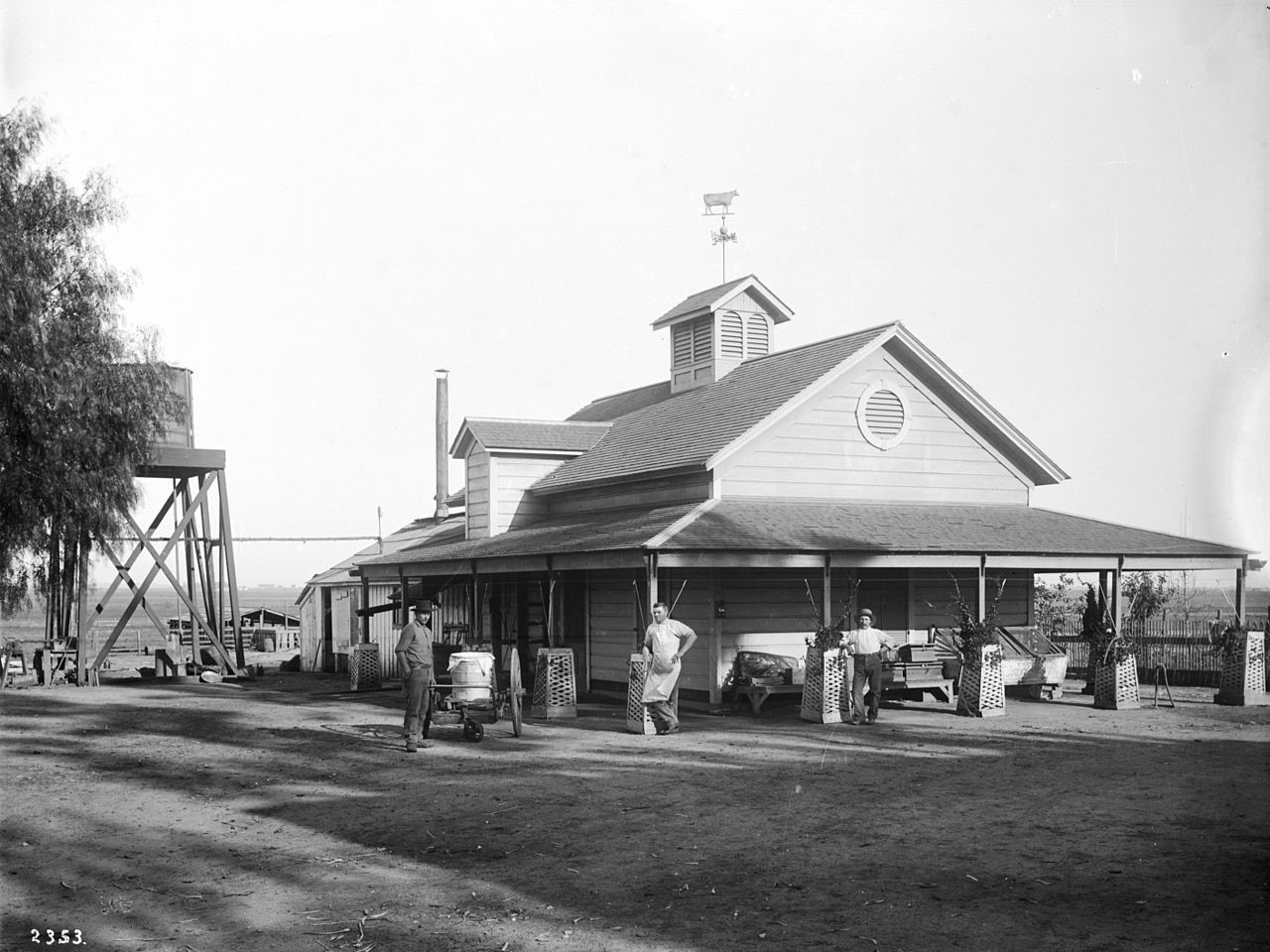
| (ca. 1905)^^ - View showing three men standing in front of the creamery on the Hammel and Denker ranch. Trellis planting boxes surround each of the wooden posts of the covered porch of the wooden creamery. A directional wind vane in the shape of a cow is on the top of the roof. A water tower is visible behind the building. Another ranch building is visible in the background. |
Historical Notes In 1900, Burton E. Green, Charles A. Canfield, Max Whittier, Frank H. Buck, Henry E. Huntington, William G. Kerckhoff, William F. Herrin, W.S. Porter, and Frank H. Balch, formed the Amalgamated Oil Company, bought the Hammel and Denker ranch, and began looking for oil. They did not find enough to exploit commercially by the standards of the time, though. In 1906, therefore, they reorganized as the Rodeo Land and Water Company, renamed the property "Beverly Hills," subdivided it, and began selling lots. The development was named "Beverly Hills" after Beverly Farms in Beverly, Massachusetts and because of the hills in the area. The first house in the subdivision was built in 1907, although sales remained slow.*^ |
.jpg) |
|
| (ca. 1910)##++ - Before being incorporated, before the Beverly Hills Hotel, before there was even "Hills," it was called just "Beverly." The above view shows Beverly Hill’s first train station located where the historic post office still stands on the southeast corner of Santa Monica Boulevard and Cañon Drive. |
 |
|
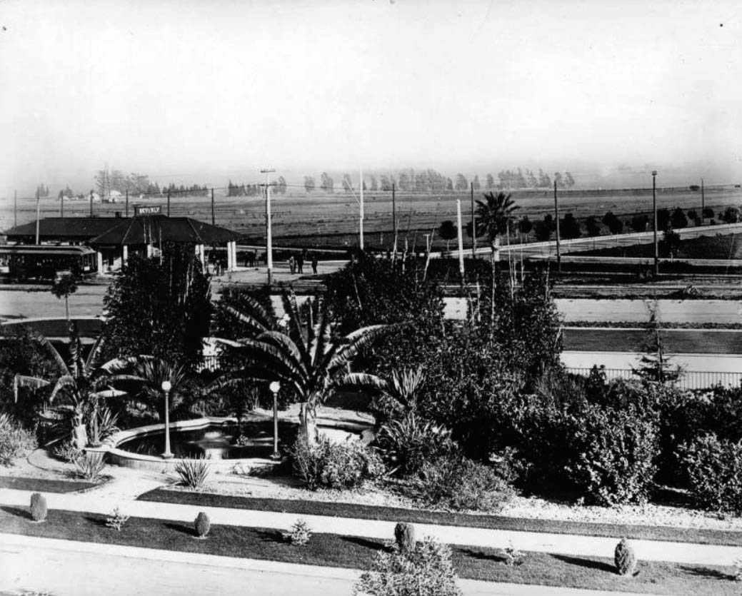
| (ca. 1918)^^ - View of Beverly Hills looking south from Sunset Park (later Will Rogers Park), showing a Pacific Electric Station. An oasis-style fountain stands in the foreground surrounded by trees, a sidewalk lining it in front. Behind this, the Pacific Electric station can be seen with a departing streetcar at left, on the corner of Beverly Drive and Santa Monica Boulevard. |
 |
|
| (1915)^ - View looking east on an unpaved Santa Monica Boulevard at Canon Drive with the Hollywood Hills in the background. |
 |
|
| (ca. 1920)*^#^ – View showing Beverly Hill’s iconic Tudor Revival Park Way house and famous lily pond in Beverly Gardens Park with its original electrified Beverly Hills sign. |
Historical Notes The area was created as a real estate attraction, hoping to entice people traveling from Los Angeles to buy parcels of land for development, and could be seen from passer byers on the train that came through town on Santa Monica Boulevard, or as it was once known, as Railway Avenue. ##++ |
 |
|
| (1912)^#^ - View of looking southwest across Lexington and Crescent Drives. The Beverly Hills Hotel and the still undeveloped surrounding area can be seen in the background. Sunset Boulevard is beyond the hotel. |
Historical Notes In September, 1911, Burton Green began construction on The Beverly Hills Hotel. It was opened on May 12, 1912 by Margaret J. Anderson and her son, Stanley S. Anderson, who had been managing the Hollywood Hotel. The visitors drawn by the hotel were inclined to purchase land in Beverly Hills, and by 1914 the subdivision had a high enough population to incorporate as an independent city. That same year, the Rodeo Land and Water Company decided to separate its water business from its real estate business. The Beverly Hills Utility Commission was split off from the land company and incorporated in September, 1914, buying all of the utilities-related assets from the Rodeo Land and Water Company.*^ |
 |
|
| (1915)#^*^ - View looking northwest on N. Crescent Drive from Lomitas Avenue. A large mansion can be seen on the right and the recently completed Beverly Hills Hotel is in the upper left. |
Historical Notes Green hired the landscape architect Wilbur D. Cook who, influenced by landscape designer Frederick Law Olmstead, created wide curving streets that hugged the hills. The City's first streets: Rodeo, Canon, Crescent, Carmelita, Elevado and Lomitas were constructed in 1907. Cook also created an emerald necklace for his garden city, with a three-block greensward called Santa Monica Park.+++ |
 |
|
| (ca. 1918)^ - Aerial view of Beverly Hills early on in real estate development. Seven roads meet just before the Beverly Hills Hotel. |
Historical Notes In 1919, Douglas Fairbanks and Mary Pickford bought land on Summit Drive and built a mansion, finished in 1921 and nicknamed "Pickfair" by the press. The glamor associated with Fairbanks and Pickford as well as other movie stars who built mansions in the city contributed to its growing appeal.*^ |
 |
|
| (ca. 1918)^^ - Aerial view of Beverly Hills showing the new Beverly Hills Hotel. The hotel is visible at center, its t-shaped main building surrounded by trees. There are two tennis courts and several smaller buildings on the hotel grounds as well. In front of the hotel is a triangular park that would later become Will Rogers Memorial Park, after the first mayor of Beverly Hills. The streets in this neighborhood curve irregularly and there are three six-way intersections visible, one at each of the corners of the park. |
Historical Notes Beverly Hills was one of many all-white planned communities started in the Los Angeles area around this time. Restrictive covenants prohibited non-whites from owning or renting property unless they were employed as servants by white residents. It was also forbidden to sell or rent property to Jews in Beverly Hills.*^ |
 |
|
| (ca. 1918)^^ - View of the Will Rogers Memorial Park (then called Sunset Park) in front of the Beverly Hills Hotel, designed by Elmer Grey. Neither has mature landscaping at this time. Note the PE streetcar at center-left. |
Historical Notes Will Rogers Park opened in 1915 as the first municipal park in the Beverly Hills, at that time called Sunset Park. In 1926, entertainer Will Rogers was appointed first "Honorary Mayor" of Beverly Hills and, in 1952, the City renamed the Park, Will Rogers Memorial Park.***^^ |
 |
|
| (ca. 1918)#+++ - Close-up view of the Beverly Hills Hotel with Pacific Electric station on Sunset Boulevard in the foreground. |
 |
|
| (1921)^ - Looking south from a vantage just above the Beverly Hills Hotel. Click HERE to see more early views of the Beverly Hills Hotel. |
Historical Notes By the early 1920s the population of Beverly Hills had grown enough to make the water supply a political issue. In 1923 the usual solution, annexation to the city of Los Angeles, was proposed. There was considerable opposition to annexation among such famous residents as Mary Pickford, Will Rogers, Douglas Fairbanks, and Rudolph Valentino. The Beverly Hills Utility Commission, opposed to annexation as well, managed to force the city into a special election and the plan was defeated 507 to 337.*^ |
 |
|
| (ca. 1919)^ - View of Beverly Hills looking north over Wilshire Boulevard. Some of the street names have been marked on the photo including Wilshire, Santa Monica, Sunset, and Crescent Drive. |
.jpg) |
|
| (1919)^ - Aerial photo of the Beverly Hills Speedway (1919 - 1924) located south of Wilshire Boulevard near where it intersect with Santa Monica Boulevard. |
Historical Notes Life during the Roaring 20s accelerated with the construction of a huge, banked wooden racetrack, dominating most of the southern section of the City. The Speedway drove Beverly Hills further toward the center of America's popular imagination via radio broadcasts of races that were on the same scale as today's Indy 500. The speedway also was sometimes used as a base for another national craze: aviation.+++ Click HERE to see more Early Views of the Beverly Hills Speedway. |
 |
|
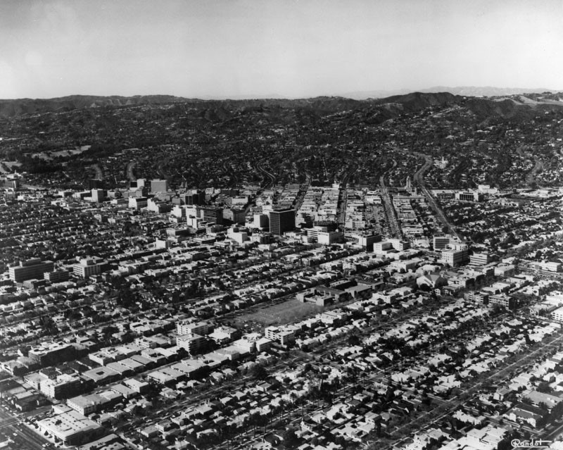
| (1970)^ - Aerial view of Beverly Hills in 1970 from a similar angle as seen in a previous photo. The row of taller (high-rise) buildings seen across the middle of the picture are along Wilshire Blvd. |
Beverly Hills (Before and After)
|
|
|
| Aerial view of Beverly Hills, circa 1919 | Aerial view of Beverly HIlls, 1970 |
Click HERE to see more Early Views of Beverly Hills |
* * * * * |
Laurel Canyon and Hollywood Hills
 |
|
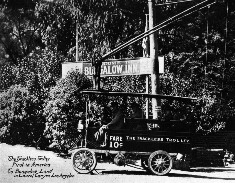
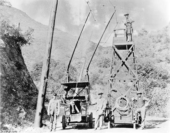
| (ca. 1912)^ - A trackless trolley, 'The First in America,' traveling to and from 'Bungalow Land' in Laurel Canyon, Hollywood. Fare was 10 cents. Sign in the background reads: Welcome to Bungalow Inn. |
Historical Notes In 1912 Charles Mann, a realtor, and Richard Shoemaker, an engineer, introduced these trackless trolleys to stimulate land sales in Laurel Canyon. The trolleys operated from Sunset Blvd. to the Tavern at the junction of Laurel Canyon and Lookout Mt. Road.^^ Mann and his partners bought property along Laurel Canyon Boulevard and up in the hills. Some of the first tracts to be developed in the Lookout Mountain bowl were Bungalow Land and Wonderland Park, both of which were moderately priced with narrow lots and a network of interconnecting lanes and foot paths. #^*^# |
 |
|
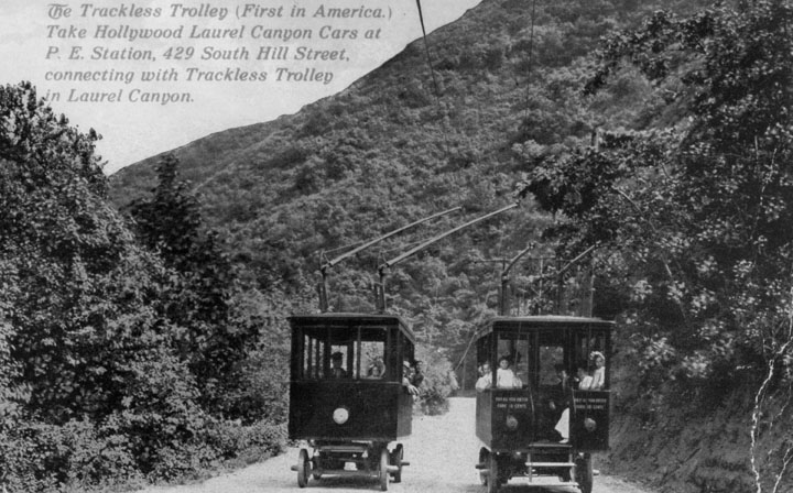
| (ca. 1912)^ - View showing two trackless trolleys passing each other on Laurel Canyon. |
Historical Notes The trolley ran along Laurel Canyon's dirt road and connected Sunset Boulevard to the base of the current Lookout Mountain Avenue where there was a small inn. The Laurel Tavern served lunch to tourists and prospective customers of Mann's Bungalow Land properties. The ride cost 10¢. More adventurous travelers could continue up Lookout Mountain Avenue for a breathtaking view of Hollywood from the area around the current Appian Way.#**^# |
 |
|
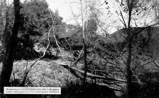
| (ca. 1912)#^*^# - View showing Charles Mann’s Bungalow Inn nestled in the lowland valley across a little spring fed stream near the present day intersection of Laurel Canyon Blvd and Lookout Mountain Avenue. |
Historical Notes Travel to the newly subdivided lots and cabins further up the canyon was at first made on foot or by mule. As the roads were improved access was possible by automobile.*^ |
 |
|
| (ca. 1912)#** - View showing a maintenance crew working on the overhead wires of the nation's first trackless trolley on Laurel Canyon. |
Historical Notes The trolley was actually a large automobile (1912 Oldsmobiles) converted to run on an electric engine connected to overhead wires, which frequently dislodged. It had an approximate 10-passenger capacity. After about 5 years of traveling up and down the treacherous narrow road, the poor old trolley buses fell apart. The overhead wires came down and the service was replaced by Stanley Steamers about 1915. **^*^ |
 |
|
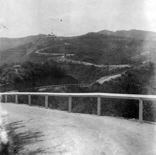
| (ca. 1912)#^*^# - View showing the road leading up to the Lookout Mountain Inn, also built by Charles Mann to promote his Laurel Canyon properties. |
 |
|
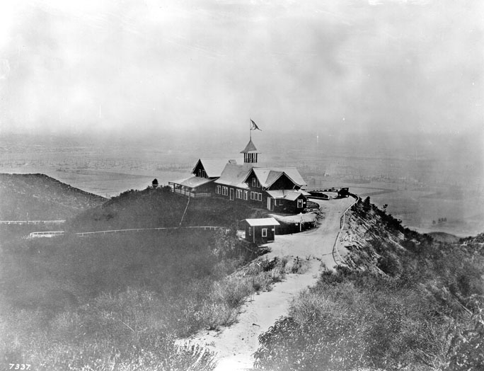
| (1916)^ - View of Lookout Mountain Inn perched high on the Hollywood Hills. It offered spectacular views of the city below. |
Historical Notes Lookout Mountain Inn lasted only four years, burning down in 1920. Charles Mann, the original developer of Laurel Canyon, is not the same Charles Mann who founded the real estate office at Kirkwood and Laurel Canyon Blvd, and there is no relation. Just a coincidence of history.#** |
 |
|
| (ca. 1916)#^*^# - Once at the top, visitors to the Lookout Mountain Inn could enjoy a broad view of the farmlands and oil fields stretching out to the ocean. |
 |
|
| (Early 1900s)^#^ - View looking southeast from Lookout Mountain towards Hollywood. If the camera were turned about 45 degrees to the right, we would be looking almost straight down La Cienega, which "points to" Lookout Mountain from West Hollywood and mid-Wilshire. |
Click HERE to see more in Early Views of Hollywood (1850 - 1920) |
* * * * * |
Ocean Park
 |
|
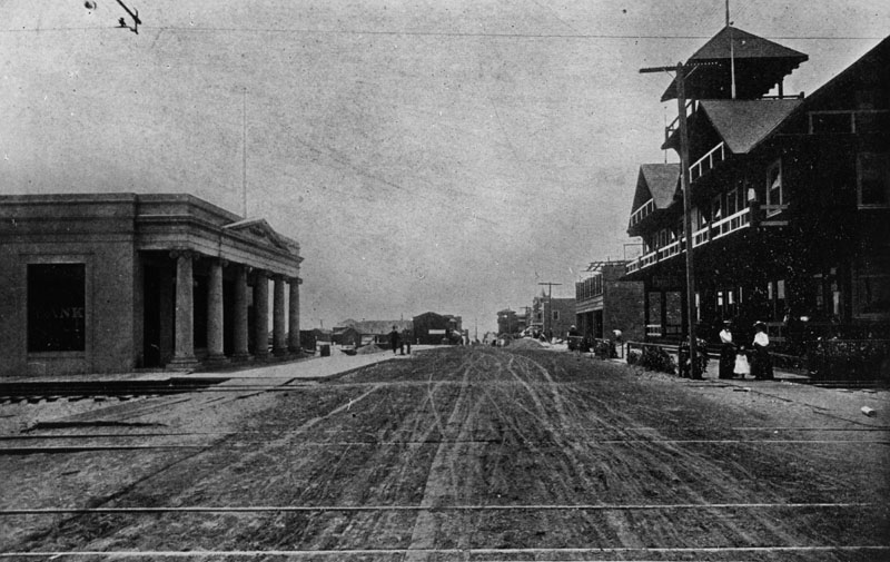
| (Early 1900s)^ - An early view down the unpaved Pier Avenue in Ocean Park. Several rail lines can be seen in the street. A bank has been built on the left and other multi-story commercial buildings on the right. The cross street may be Trolley Way. |
 |
|
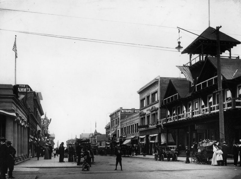
| (1905)^ - The same view down Pier Avenue a few years later, with buildings on both sides of the street, and cars and horse drawn carriages parked in front of the stores. |
Click HERE to see more in Early Views of Santa Monica |
* * * * * |
Downtown Los Angeles
 |
|
| (1913)^ - An aerial view taken where Spring St. and Main St. split at 9th St. Looking north we have Spring St. on the left and Main on the right. At center-left can be seen the Copeland Building (aka Armory Building), located on the NW corner of Spring and 8th streets. |
Historical Notes The junction of Main, Spring, and 9th streets became one of the most photographed intersections because of its configuration. Click HERE to see more. |
 |
|
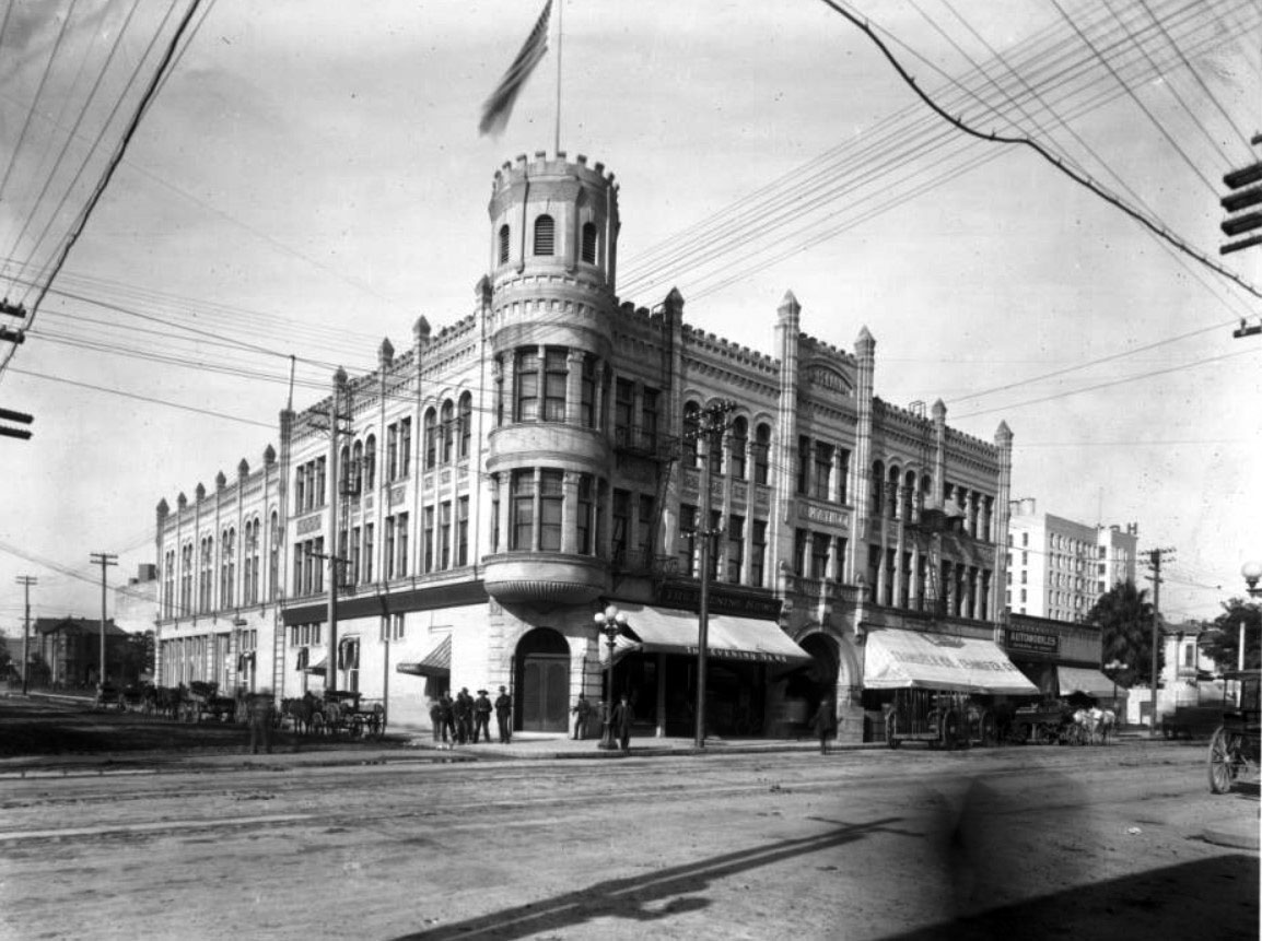
| (ca. 1908)^^ - View looking at the northwest corner of Spring and 8th streets showing the Copeland Building (aka Armory Building). The castle-like building stands about three-stories tall. An American flag stands on top of the tower (corner of building). The tower, like the rest of the building, has battlements all the way around it. Buttresses with pyramid-like spires reinforce the building's structure at intervals all around the building. A dozen men stand around at the corner of the street. |
Historical Notes For many years, the armory building had a mix of military and civilian uses that would seem unthinkable today. The lot was privately owned and developed by John S. Copeland, and the National Guard shared the building with three storefronts along Spring Street. Nonetheless, the armory was one of the most well-appointed military buildings in California, equipped with a drill hall, saddle room, officers’ quarters, reception rooms, and a gymnasium. It was also one of the few Romanesque Revival buildings whose turret was built with a functional purpose: the easy mounting of a Gatling gun (that convenience never became a necessity, thankfully). |
 |
|
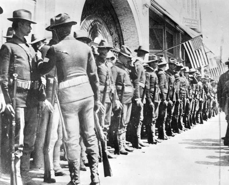
| (ca. 1917)^ - Members of the 7th California Volunteers line up in front of the Copeland Building, the location of the old armory at 8th and Spring streets, before departing for San Francisco. |
 |
|
| (1913)^ - View of South Hill Street from below 6th Street. A trolley may be seen on the tracks in the middle of the road. Note the ornate streetlights running on both sides of the street. |
 |
|
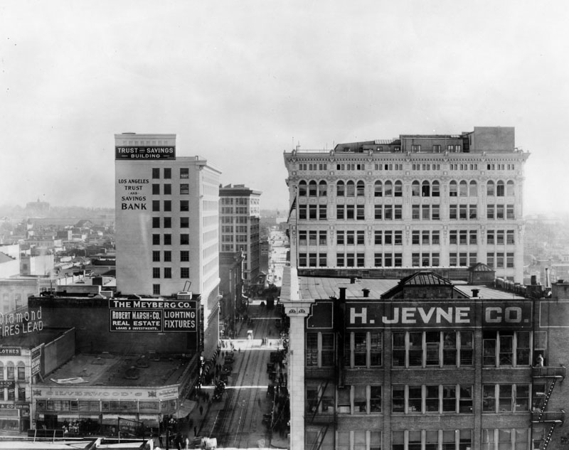
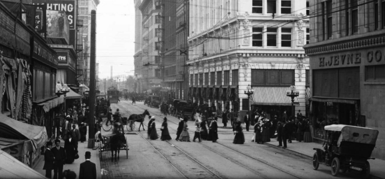
| (1913)^ - View of 6th Street looking east from Broadway. On the left corner is the Silverwood's men's clothing store, next to which is The Meyberg Co., sellers of lighting fixtures, and Robert Marsh & Co. Real Estate. Behind it is Los Angeles Trust and Savings Bank. In the right foreground is H. Jevne Co. Cars are parked on the street next to streetcar tracks. |
 |
|
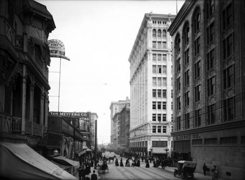
| (1909)^^ – View looking east on 6th Street from Hill Street toward Broadway. The left side of the street is lined with small buildings containing shops, while the right side has several large buildings that are at least six stories high. |
Historical Notes Legible signs include, from left to right, "Hennelly Hat Manufacturer", "Rooms", "The Meyberg Co.", and "H. Jevne Co.". The photograph features the following buildings: Lindley Building (built in 1887) can be seen at immediate left, while John H. Norton Block (built in 1906) is visible at immediate right ("H Jevne Co"). Walter P. Story Building (built in 1909) can be seen located at south-east corner of 6th Street and Broadway; Hotel Hayward (built in 1906) is visible at south-west corner of 6th Street and Spring Street; Grosse Building (1906-1957) at south-east corner of 6th Street and Spring Street; Pacific Electric Building (built in 1904) at south-east corner of 6th and Main; Kerckhoff Building (built in 1908) on the north-east corner of 6th Street and Main Street. |
 |
|
| (1909)^^ – Close-up panoramic view of the intersection of 6th Street and Broadway looking east. Streetcars, early model cars, horse-drawn wagons, and pedestrians share the street. |
Historical Notes Note the license plate on the automobile at the near right. It is what was called a "dogbone" -- porcelain on metal plate, -- issued by the Automobile Club of Southern California from 1909-1913, before the State began issuing license plates. |
 |
|
| (1906)^ - View looking north on Hill Street with Central Park (Pershing Square) on the left. First Methodist Episcopal Church is on the right corner, on the N/E corner of 6th and Hill Streets. |
 |
|
| (1906)^ – Postcard View looking north on Hill Street showing a horse-drawn wagon with two men heading toward 6th Street. The First Methodist Episcopal Church can be seen on the N/E corner with streetcar in front of it. Across the street on the left is Central Park (Pershing Square after 1918). |
Central Park (Pershing Square after 1918)
 |
|
| (1909)#*^ – Panoramic view looking north on Hill Street from over 6th Street with the First Methodist Episcopal Church seen in the lower-right (S/E corner). Central Park (later Pershing Square) is across the street on the left. On the north side of the park can be seen the Auditorium Building on the left. To its right is the California Club Building, on the N/W corner of Hill and 5th streets. |
Historical Notes The following is a chronology of name changes the park has seen before becoming Pershing Square: ◆ 1866 – La Plaza Abaja or "The Lower Plaza" ◆ 1867 – St. Vincent Park ◆ 1870 – Los Angeles Park ◆ 1886 – 6th Street Park ◆ 1890s- Central Park ◆ 1918 – Pershing Square |
 |
|
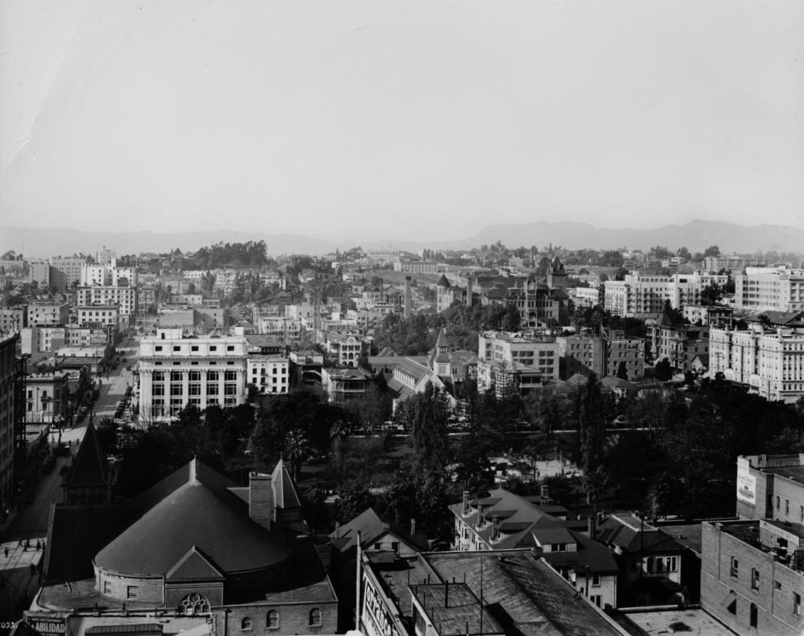
| (ca. 1910)* - Looking NW with the Hollywood Hills in the distant backgroung (upper right) and Central Park (later Pershing Square in the foreground. The domed roof of the First Methodist Episcopal Church (NE corner of Hill and 6th) can be seen in the lower left. The Mutual Life Insurance Building, in white, can be seen across the park on the NW corner of Olive and 6th Street. The State Normal School can be seen at upper center right (Grand and 5th Street). Also, the 1883-built St. Paul's Cathedral stands on the other side of the park at center of photo. |
 |
|
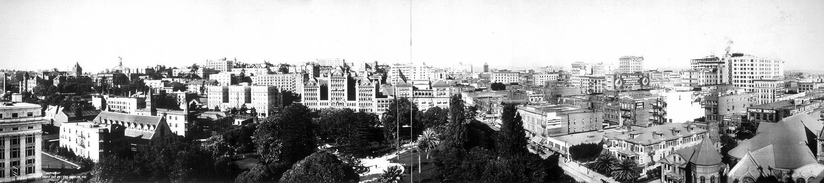
| (ca. 1911)^ - Panoramic view of Los Angeles looking northwest from 6th and Hill over Central Park (later Pershing Square). |
 |
|
| (ca. 1912)^ – Postcard view showing Central Park (later Pershing Square) from Broadway and Fifth Street. The Pacific Mutual Life Insurance Building can be seen at left-center and at lower-left is the First Methodist Episcopal Church. |
Historical Notes In 1867, St. Vincent's College, present day Loyola Marymount University, was located across the street, and the park informally became called St. Vincent's Park. In 1870, it was officially renamed Los Angeles Park (Click HERE to see Early Views Los Angeles City Park). In 1886 it was renamed 6th Street Park, and redesigned with an "official park plan" by Frederick Eaton, later the mayor. In the early 1890s the park was renamed Central Park, which it was called for decades. In November 1918, a week after Armistice Day ended World War I, the park was renamed Pershing Square, in honor of Gen. John Joseph "Black Jack" Pershing.*^ |
 |
|
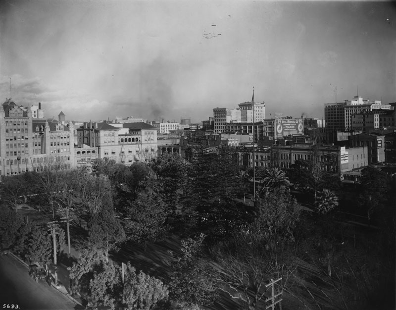
| (ca. 1913)^ - View of the Central City looking northeast over Central Park (Pershing Square) from 6th and Olive. |
 |
|
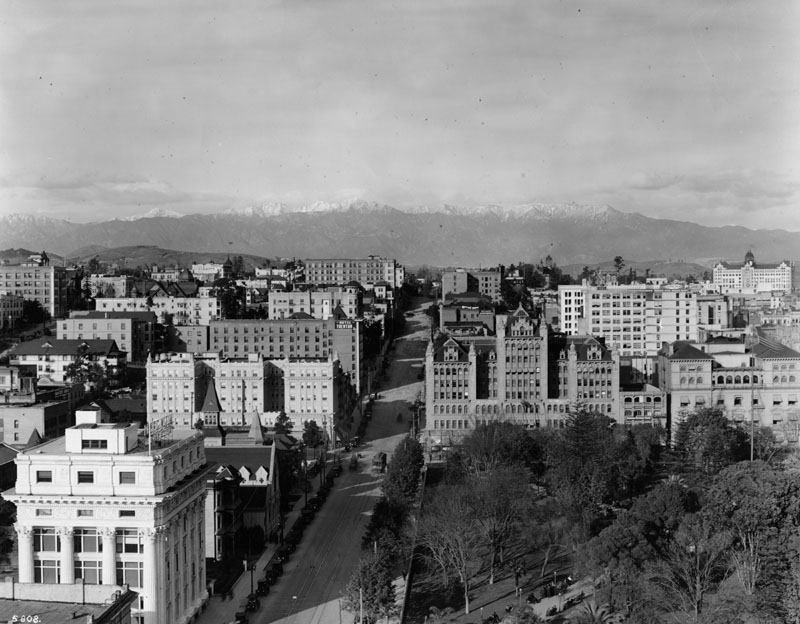
| (1913)^ - Panoramic view of Olive Street looking north from 6th Street in 1913 toward snow-capped mountains. At left is the Pacific Mutual Life Insurance Building, and at right is Pershing Square. Beyond it is the Auditorium Building. Various other buildings are seen in this view taken from the Los Angeles Athletic Club building on 7th and Olive. The afternoon sun bathes them in a strong light. |
 |
|
| (1913)^^ – View looking north on Hill Street from over Pershing Square. The California Club Building stands on the northwest corner of 5th and Hill streets to the left. In the far distance can be seen (l to r): Los Angeles High School, Hall of Records, County Courthouse, and City Hall. |
 |
|
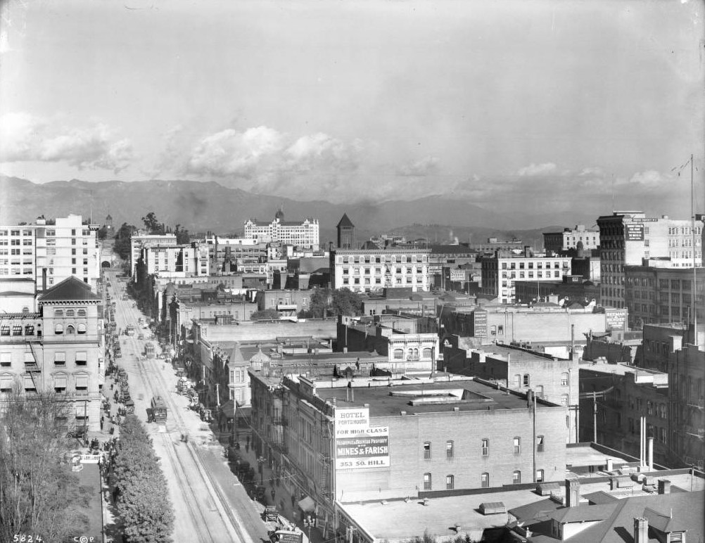
| (1913)^^ – Close-up view of the intersection of Hill and 5th streets looking north. On the southeast corner stands the Willoughby Hotel with its domed tower. Next to it in the foreground is the Hotel Portsmouth at 353 S. Hill Street. |
 |
|
| (ca. 1913)^^ - View lookikng east on 5th Street at its intersection with Hill Street showing the Willoughby Hotel on the southeast corner. Central Park (renamed Pershing Square in 1918) is in the foreground. The edge of the California Club can be seen across the street on the northwest corner. |
 |
|
| (ca. 1913)^^ – View looking east on 5th Street showing Central Park (now Pershing Square) at center as seen from the State Normal School at Grand Ave. The next street over is Olive where the impressive Auditorium Building stands on the northeast corner. |
 |
|
| (1913)^ - View looking north showing the buildings facing Pershing Square (at the time Central Park) on the north side of 5th Street. The Auditorium Building sits on the northeast corner of Olive and 5th (center-left) and the California Club Building is on the northwest corner of Main and 5th streets (right). |
 |
|
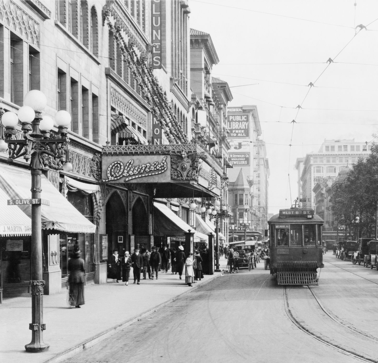
| (ca. 1914)^#^ - View looking east on 5th Street at the corner of 5th and Olive. The Clune's Auditorium (Auditorium Building) is seen on the north side of 5th Street across from Pershing Square and the California Club Building is behind it. A horse-drawn carriage is seen parked by the curb while a streetcar is in the middle of the road. Note the details on the ornate streetlight on the corner. Click HERE to see more in Early Los Angeles Streetlights. |
Historical Notes In 1914, the theatre was leased to pioneer showman Billy Clune and became the grandest movie palace west of New York. There was (still) church on Sundays, lots of concerts, and feature films with elaborate prologues.**^* |
 |
|
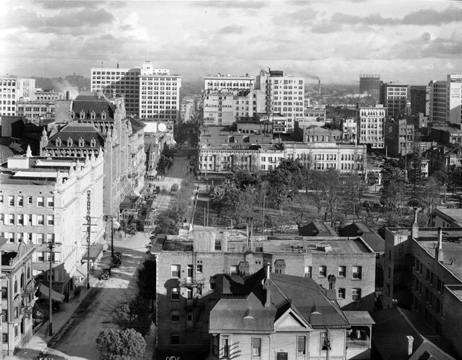
| (1915)^*# - View looking west on 5th Street toward Olive. The tall building in center of photo is Clune's Auditorium. The California Club is at right and across the street is Central Park (Pershing Square). The State Normal School building with its pointed towers can be seen at the end of 5th Street at Grand Ave (Current location of the LA Central Library). |
Historical Notes Clune's Auditorium was much influenced by the design of Sullivan's Auditorium Theatre in Chicago. The eight story building had retail on the 5th Street side, a basement banquet hall, two 950 seat halls on the second floor, 118 office/studio spaces plus the main auditorium. The theatre was used on Sundays by the Temple Baptist Church.**^* |
 |
|
| (ca. 1920)^*# - View of Central Park (Pershing Square) looking north. The tall building with the arched sign on the roof (behind the flagpole) is the Clune's Auditorium located on the northeast corner of Olive and 5th streets. Click HERE to see more Early Views of Central Park as it appeared in the 1800s. |
Historical Notes The building was known until 1920 as Clune's Auditorium and (sometimes) Clune's Theatre Beautiful. Even though its movie career was brief, given the size of the theatre, the impressive architecture and Clune's dazzling productions, this building ranks as the first true Los Angeles movie palace. Clune used a 20 piece orchestra and reserved the biggest pictures he could get for this venue.**^* |
 |
|
| (ca. 1920)^ - View looking north on Olive Street at 5th Street. The Auditorium Building (also known as Clune's Auditorium) is seen on the northeast corner of the intersection, across the street from Pershing Square. |
Historical Notes This is where the LA Philharmonic played until the Dorothy Chandler Pavilion opened in the mid-1960s. This building replaced an older building called Hazard's Pavilion and was dedicated in 1906. For a while, silent films were shown there, and it was known as Clune's Auditorium. It became the Philharmonic Auditorium in around 1920. In 1920, the Los Angeles Philharmonic moved into this building in its second year of existence.*^ |
 |
|
| (ca. 1920)* – View looking west on 5th Street at Hill Street with Pershing Square seen on the left. |
Historical Notes The following is a chronology of name changes the park has seen before becoming Pershing Square: ◆ 1866 – La Plaza Abaja or "The Lower Plaza" ◆ 1867 – St. Vincent Park ◆ 1870 – Los Angeles Park ◆ 1886 – 6th Street Park ◆ 1890s- Central Park ◆ 1918 – Pershing Square ^* |
Then and Now (Blended View)
 |
|
| (1920 v. 2020)* – Hill and 5th streets looking west. Blended image by Mark Hersch |
Click HERE to see more Early Views of Pershing Square in the 1930s |
* * * * * |
4th Street and Grand Avenue
 |
|
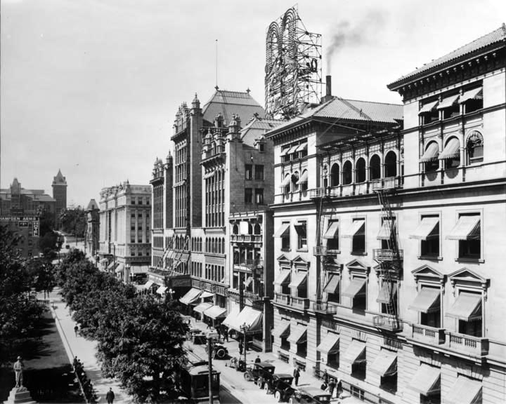
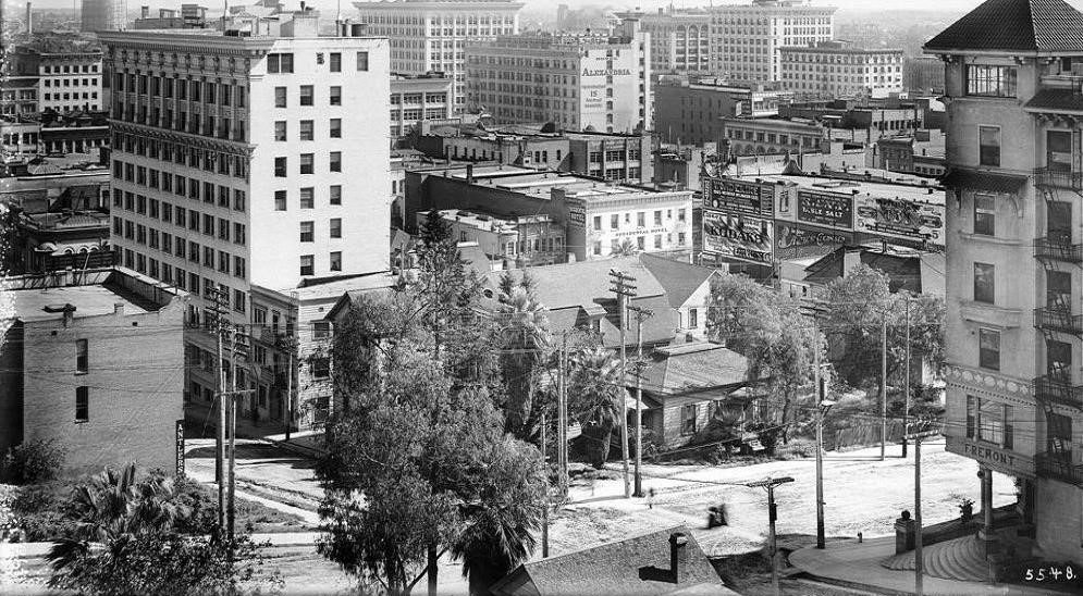
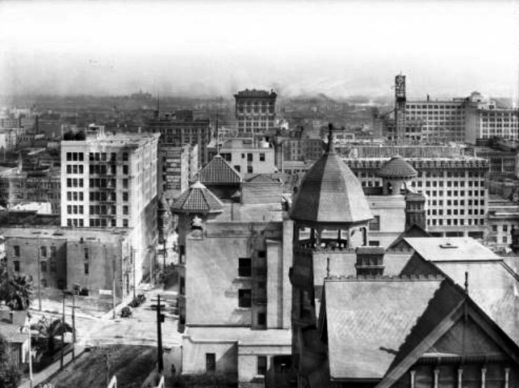
| (ca. 1910)#^ - View looking southeast from 4th Street and Grand Avenue. On the right with the curved stairs is the Fremont Hotel. At the lower left, the building with the essentially blank wall sporting only two vertical windows is the little Hotel Antlers on the NW corner of Clay and 4th Streets. The prominent back of the Wright and Callender Building (11 stories) is here on the left in the middle distance at 4th and Hill Streets and at the upper-center we can see the back of the Hotel Alexandria on the SW corner of 5th and Spring Streets. The Occidental Hotel is clearly visible due to the P.E. subway building being as yet un-built and next to it, on the left, we can see the itty-bitty Hotel Leroy which will give way to the coming of the enormous Hotel Clark. |
 |
|
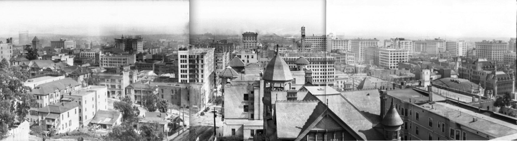
| (ca. 1913)^^ – Composite panoramic view of Los Angeles, looking east from the corner of 4th Street and Grand Avenue on Bunker Hill. In the lower right is the Rose Mansion, on the SE corner of Fourth and Grand. Beyond it is the distinctive multi-turreted roof of the Fremont Hotel, on the SW corner of 4th and Olive. |
Olive and 4th Streets
 |
|
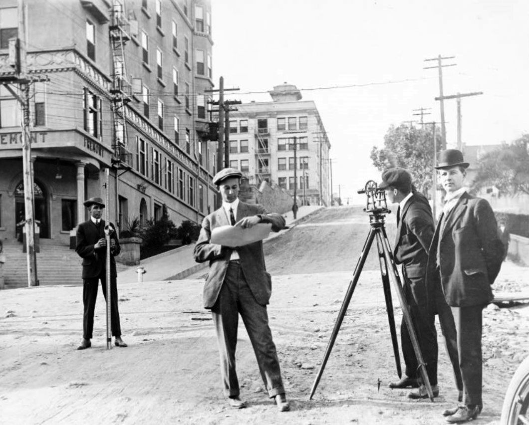
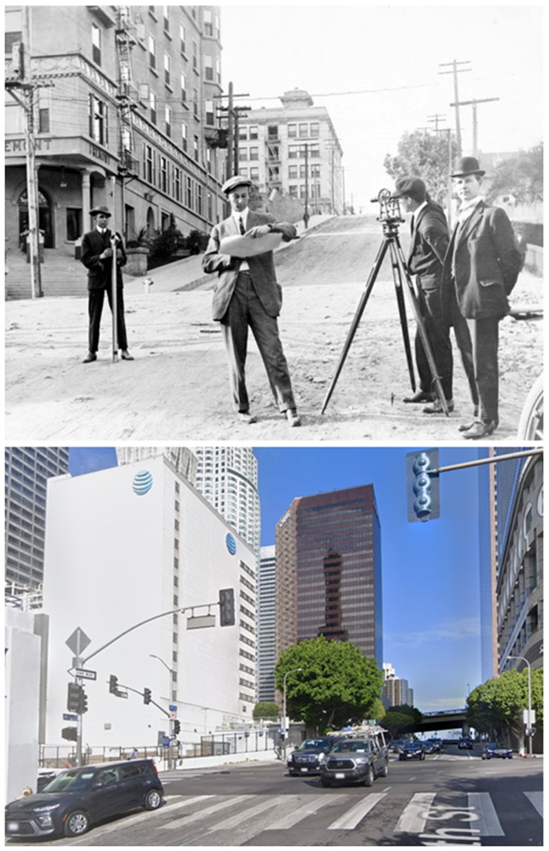
| (1912)* - View looking west on Fourth Street showing three engineering students and a professor from USC surveying at the intersection of Fourth and Olive streets. The Fremont Hotel stands on the southwest corner and the Zelda Apartments can be seen in the background on top of the Bunker Hill. |
 |
|
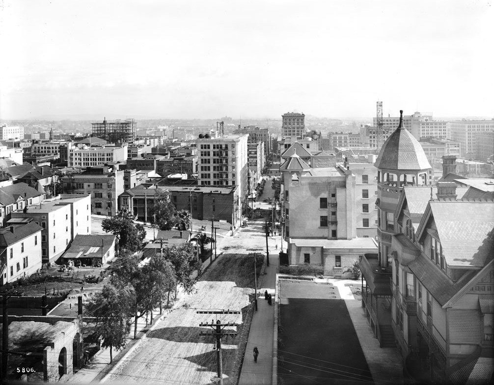
| (1913)^^ - View looking east on 4th Street from the roof of the Zelda Apartments. The intersection of 4th and Olive can be seen at center of photo. The Rose Mansion is seen at lower-right. |
Historical Notes The ornate roof with open turret in the immediate right foreground is the private residence of businessman, horse-breeder and noted vintner Leonard J. Rose on the SE corner of Grand and 4th (400 S. Grand), beyond it is the distinctive multi-turreted (only two are visible here but there are three and they are distinct from each other) roof of the Fremont on the SW corner of 4th and Olive. Just peeking over the top of the Fremont we have the top floor of the Wright & Callender Building at SW 4th and Hill Street and to the left of that we have the Black Building (ironically the big white building) NW 4th and Hill. Behind the Black Building (nearer the camera) is the red brick Antlers Hotel and then, at the corner of 4th and Olive, a vacant lot which will soon be occupied by the Hotel Clark parking garage (The Hotel Clark, still under construction, appears above and to the right of the Fremont roof line and seems to be three or four floors short of topping out). #^ |
 |
|
| (ca. 1913)^^ – Closer view looking southeast from Fourth Street and Grand Avenue. Fourth Street runs vertically (at left) with Olive Street intersecting it horizontally (visible at left). In the lower right is the Rose Mansion, on the SE corner of Fourth and Grand. Beyond it is the distinctive multi-turreted roof of the Fremont Hotel, on the SW corner of 4th and Olive. |
 |
|
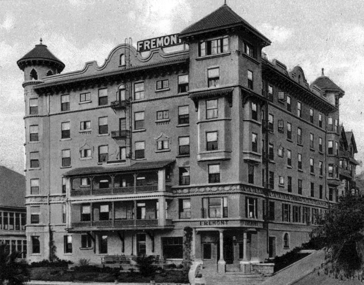
| (n.d.)^ - Postcard view of the Fremont Hotel on the southwest corner of 4th and Olive, showing the 6 story building, with corner turrets and balconies on one side for the 2nd and 3rd floors. Architect, John Austin. |
Historical Notes The Fremont Hotel, located in the Bunker Hill suburb, was built and designed by the architect John C. Austin and developed by Thomas Pascoe. The plans for building the hotel were developed in November 1901 and initially faced resistance from the next door Olive Street School establishment. It was designed by the architect in the Mission style, and had some 100 rooms. It opened on September 9, 1902 and was named after John C. Frémont. When newly built it was billed as "the newest and most elegantly appointed family hotel in Los Angeles.” The hotel also held dinners in tribute to Frémont. Frémont's widow, Jessie, was the first registered guest. She also designed and executed the hotel's crest. Frémont's motto, "Eternal vigilance is the price of safety" was adopted as the hotel's motto, paraphrased into "Eternal vigilance is the price of success in the hotel business". The hotel was demolished in 1955 by the Community Redevelopment Agency, and what remained was only the retaining wall next to the Olive Public School.*^ |
Then and Now
 |
|
| (1912 vs 2022)* - Looking west on Fourth Street at Olive Street showing three USC engineering students and their professor doing surveying at the intersection. The Fremont Hotel can be seen on the left (SW corner). |
Grand and 4th
 |
|
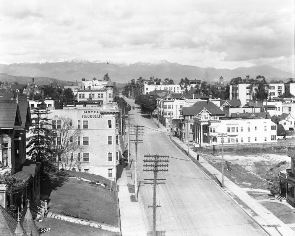
| (ca. 1913)^^ - View of Grand Avenue looking northeast from 4th street. A majority of the buildings are homes, hotels or apartment buildings. Legible signs include: "the Minnewaska", "Hotel Fleur-de-lis", "tailoring", "millinery". |
Los Angeles Fire Department
.jpg) |
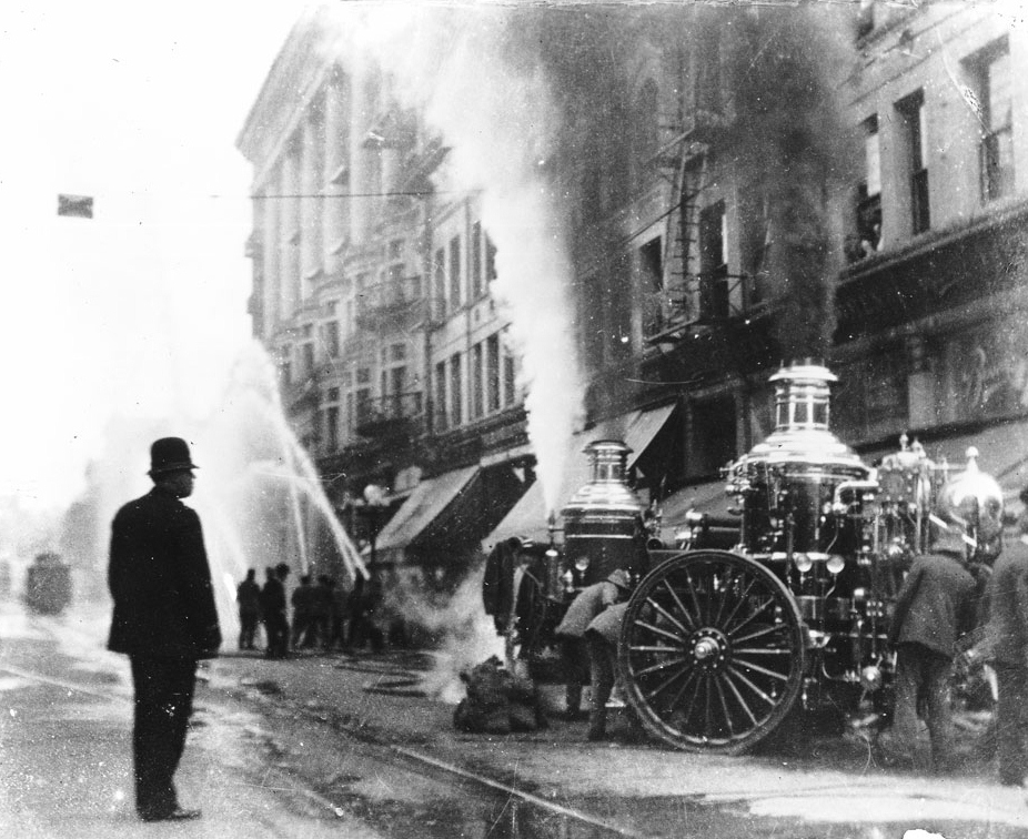
|
| (ca. 1913)^^ - View of the Los Angeles Fire Department fighting a fire on Broadway just north of Third Street. Fire hoses lay in a tangle on the street in the foreground, while firefighters blast a burning building with water to the left. A water pump with spoked wheels stands at left, with a larger pump surrounded by firefighters standing to the right. A third machine appears to be connected to the streetcar cables that hang over the street. City Hall stands to the right in the background. |
.jpg) |
|
| (1913)^^ - View of a 3-alarm fire on the west side of Broadway north of Third Street. Four steam water pumps surround hoses which are spread all over the street as firefighters shoot streams of water at the burning building. |
 |
|
| (ca. 1913)^^ - Fighting a fire on Broadway in downtown Los Angeles. A policeman watches as a group of firefighters operate two steam driven water pumps. In the background another group of firefighters shoot water at the fire. |
Sunset Park (later La Fayette Park)
 |
|
| (1913)^^ - View lookng northwest from the roof of the Bryson Apartments showing Sunset Park (later La Fayette Park). The angled street at the left-hand side is Wilshire; the street across the center (near top of the park) is Commonwealth, which intersects with Sixth Street (street car is at the corner). A white sign board seen in the center left is the future site of the Town House Hotel; a large vacant lot at Sixth, Commonwealth and Hoover is the future site of the First Congregational Church; and a clump of trees in the middle distance on the right is the future site of Felipe de Neve Branch Library. |
Historical Notes Clara R. Shatto donated 35 acres of land that now makes up Lafayette Park to the City of Los Angeles in 1899. The land consisted of tar seeps and oil wells and Shatto requested that it be developed into a park. Shatto was the wife of George Shatto, then-owner of Santa Catalina Island. Canary Island palm trees and jacaranda were planted in the area of what became known as Sunset Park.*^ |
 |
|
| (ca. 1913)#+ – Postcard view looking east on Wilshire Boulevard showing a woman posing in front of a palm tree at the edge Sunset Park (later Lafayette Park). The structure in the distance is the Bryson Apartment Building (built in 1913). |
Historical Notes Local groups requested that the park's name be changed to commemorate Marquis de Lafayette, a military officer of the American Revolutionary War. The name was officially changed in 1918. A statue of him was erected in 1937, close to the Wilshire Boulevard entrance.*^ |
 |
|
| (1917)^ - View looking southeast of Sunset Park (later Lafayette Park). The Bryson Apartment Building, located at 2701 Wilshire Boulevard, is on the far side of the park. This part of the park was located on West 6th between Benton Way and South Commenwealth Avenue. |
Historical Notes The l0-story Bryson Apartment Hotel (at Wilshire and Rampart) was built in 1913 and dominated the landscape at the time. It was the first of the area's distinguished high-rise apartment buildings and hotels. Later it would be owned by film actor Fred MacMurray. |
 |
|
| (ca. 1920)^ - Aerial view looking down at Lafayette Park (previously Sunset Park). Three large apartment buildings can be seen: lower left, Hershey Arms; center, The Bryson Apartments on the northwest corner of Wilshire and Rampart Boulevards; and right, Rampart Apartments on the southwest corner of 6th Street and Rampart Boulevard. |
* * * * * |
Early Public Transportation
 |
|
| (1914)^ - Pacific Electric's new El Segundo line, which began operations in August 1914. This line offered passenger service until 1930. A man is walking along the railroad track as another leans against a rail car. |
Historical Notes El Segundo was founded in 1911. Later it became the fastest growing town in California. El Segundo's greatest growth took place in the 1940-1950 decade." The city of El Segundo was actually incorporated in 1917. The area was originally part of Rancho Sausal Redondo (Ranch of the Round Clump of Willows). It was named El Segundo because it was to be Standard Oil's second oil refinery in California.^ |
 |
|
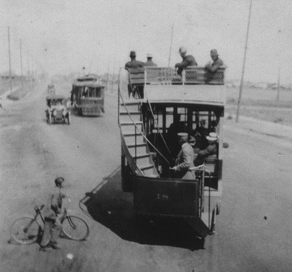
| (1914)^ - A young boy on a bicycle waits as a bus passes by on Washington Boulevard. This early type of motor coach transportation shows a double-decker bus; the upper deck filled with passengers. This bus travels from Los Angeles to Venice. |
 |
|
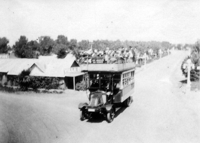
| (1914)^ - Early type of motor coach transportation between Los Angeles and Venice. The double-decker bus appears to be filled to capacity with passengers. |
 |
|
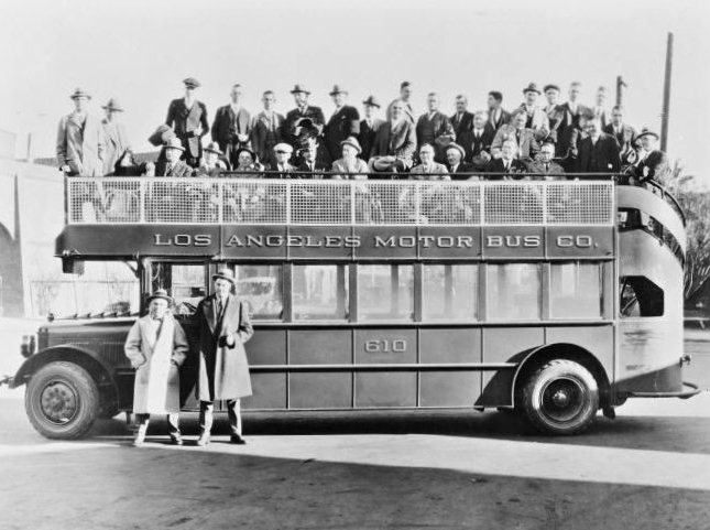
| (ca. 1920s)^## - This double-decker bus no. 610 was part of the Los Angeles Motor Bus line, built by Fageol in 1924. |
Historical Notes Los Angeles Motor Bus (later renamed the Los Angeles Motor Coach Company) was a joint venture of Pacific Electric and Los Angeles Railway that existed from 1923 until 1949. It began in 1923 as Wilshire Boulevard's transit service from the MacArthur Park area to La Brea Avenue and was extended further down Wilshire as the service gained in popularity. Wilshire has an interesting distinction, it was the only street that was banned by the City of Los Angeles from having street rail on it. The elites of early 20th century Los Angeles who built their mansions in the area were the region's first "NIMFYs" (Not in My Front Yard). The clanging bells and masses who rode streetcars were not welcomed on Wilshire, but buses were.^## |
* * * * * |
Windsor Square
 |
|
| (1914)^#^ - View of a 3-lamp streetlight on the corner of Wilshire and Windsor boulevards. Two large homes can be seen in the background. This shows the west side of the 600 south block of Windsor Blvd. in Windsor Square. |
Historical Notes Both houses in the above photo, dated November 7, 1914, amazingly resemble in design some of the newer large homes being built today. The house on the left was built in 1911 and the house on the right in 1914.^#^ |
Click HERE to see more in Early L.A. Streetlights |
 |
|
| (1915)^*# - Looking west on Santa Monica Boulevard with Mount Lee in the background. This may be very near the eastern terminus at Sunset Boulevard. #^ |
 |
|
| (ca. 1915)* - View of Hill Street between 4th and 5th. Victorian houses converted into businesses are sandwiched between the Hotel Leroy on the right and Hotel Sherman, corner of 4th and Hill, on the left. The Los Angeles Water Department (Later DWP) is to the left of Hotel Leroy. A bicycle is unattended at the curb. In the background is the Grant Building which later became the site of Hotel Clark. Click HERE to see more Early DWP Branch Offices. |
 |
|
| (1914)*^#^ - View of rush hour showing Los Angeles Railway trolley cars lined up on East 7th Street, waiting their turn to cross the equally busy Main Street. |
Historical Notes All of these trolleys, and much of downtown Los Angeles, was receiving electricity from the new Big Creek power plants which were built and owned by Pacific Light and Power Corporation. In 1917, the Edison Company (SCE) bought out the Pacific Light and Power Corp. 1922, the Bureau of Power and Light purchased SCE’s distribution system within the Los Angeles city limits. SCE’s distribution lines were limited to the territories annexed to the city since 1922, but still furnished a proportion of the power distributed by the LA Bureau of Power and Light. After the construction of Hoover Dam (1935), the Bureau of Power and Light (later DWP) had more than enough electricity to furnish the entire city of L.A. Click HERE to see more in First Electricity in Los Angeles. |
 |
|
| (1915)^ - A view of 7th St. as it crosses Spring St., looking west. Far down on the right side (north side) of 7th the sign for Bullock's Dept. Autos, electric streetcars, horse-drawn wagons, and pedestrians all share the streets. |
Historical Notes Note the elevated kiosk/booth on the northwest corner of 7th and Spring streets. These were used by the Los Angeles Railway and the Yellow Cars as a switchman’s tower to control the flow and path of streetcars through the intersection. |
 |
|
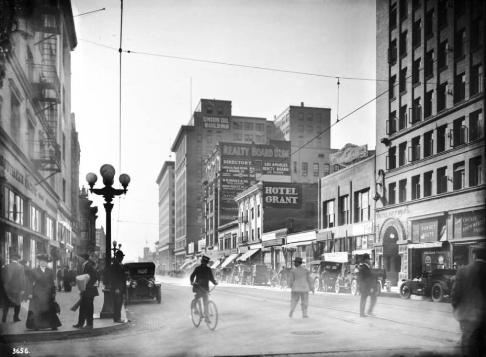
| (ca. 1914)^^ - View of Spring Street looking south from 6th Street. Pedestrians are crossing the street and walking on the sidewalk. A man in what appears to be a uniform is riding a bicycle and cars are parked along both sides of the street. The Hotel Grant is seen in the center of the photo. A beautiful 5-lamp streetlight stands on the corner. |
 |
|
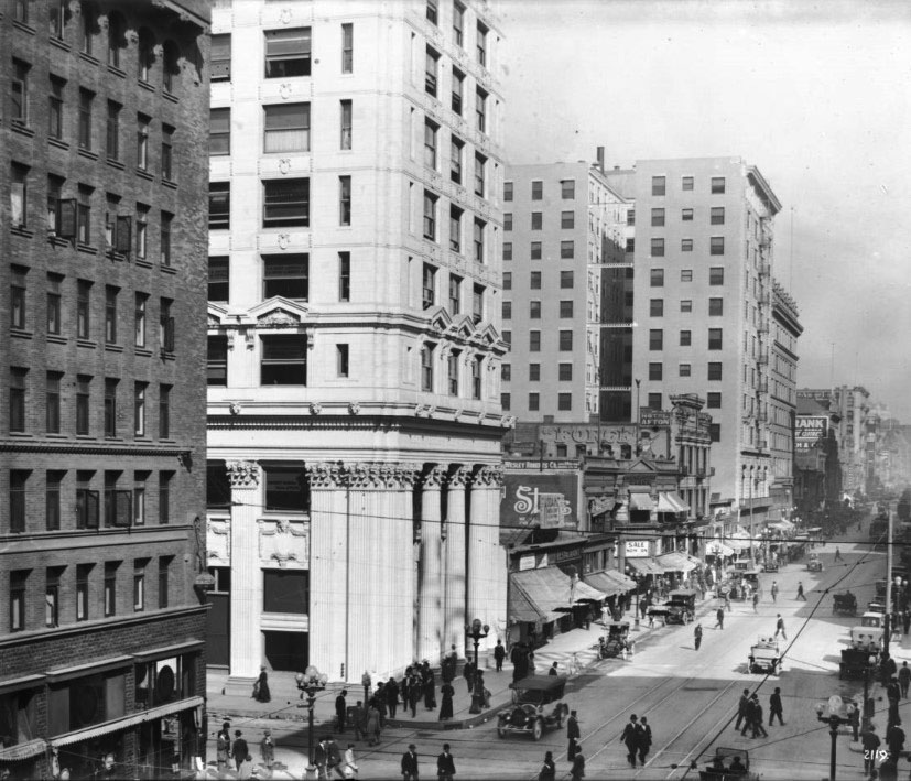
| (1915)^^ – View looking north on Spring Street from 6th Street. The tall white building on the northeast corner is the Los Angeles Trust and Savings Bank, built in 1910. |
Historical Notes By the 1910's Spring Street had become the city’s financial and banking center. |
 |
|
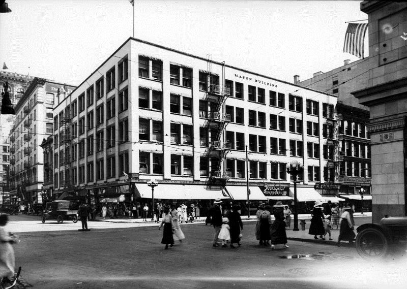
| (ca. 1915)^ - Cable cars, cars, bicycle riders and pedestrians can be seen along Broadway. On the right side is the old Mason Building located on the southeast corner of Broadway and 4th Street. |
Historical Notes The tall tower in the distance is the Old City Hall, located at 226 Broadway. It stood from 1888 until 1928. This was Los Angeles' third City Hall. |
 |
|
| (ca. 1916)^ - View of the intersection of 4th and Broadway where the Mason Building stands on southeast corner. A policeman is directing traffic while standing in the middle of the intersection and pedestrians are seen crossing 4th Street. |
Historical Notes In 1894, the Los Angeles Chamber of Commerce moved into its new quarters at the southeast corner of Broadway and 4th, in a building designed especially for its use, the then-new three-story Mason Building - which would serve as its home for twelve years. The building would later be enlarged and used as a Broadway Dept. store but eventually it would be abandoned.^ |
 |
|
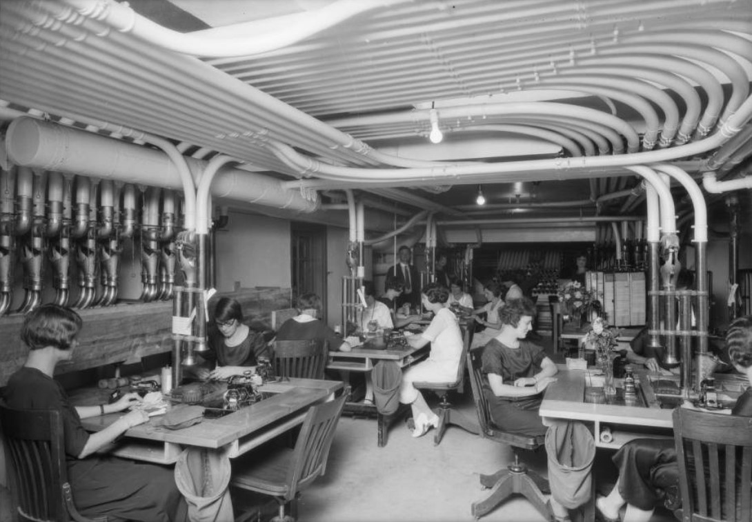
| (ca. 1925)^^ - Photograph of women working with machinery at The Broadway Department Store, 4th and Broadway. |
 |
|
| (ca. 1916)^ - 6th Street looking west from Olive Street. At right is the Pacific Mutual Life Insurance Co. building. Pershing Square is at close right. In the distance is the Jonathan Club. A streetcar bears the destination of Bimini Baths. At left is a sign, "Edwards Wildey." |
Historical Notes The Pacific Mutual Building, located at 523 W. 6th Street, was built between 1908 and 1912. From 1916 to 1926 the building was modified and expanded to include: a north side addition, another 12-story structure, a garage building, and a west side addition. In essence, it became three interconnected buildings by 1926.^ The Pacific Mutual Building is listed as Historic-Cultural Monument No. 398. Click HERE to see complete listing. |
 |
|
| (1916)^ - View looking east along 6th Street from Flower Street. Large structure on Hope Street is the Church of the Open Door/Biola Institute. |
Historical Notes The Church of the Open Door was conceived by R. A. Torrey who had come to Los Angeles to start a Bible institute (now known as Biola University) similar to Moody Bible Institute. For 70 years the church was located in downtown Los Angeles on Hope Street. It relocated to Glendora, California in 1985. Originaly financed by Union Oil magnate Lyman Stewart, the Bible Institute Church was to be strictly non-denominational, though Evangelical. Stewart also founded the Pacific Gospel Mission (now the Union Rescue Mission) in 1891.*^ |
 |
|
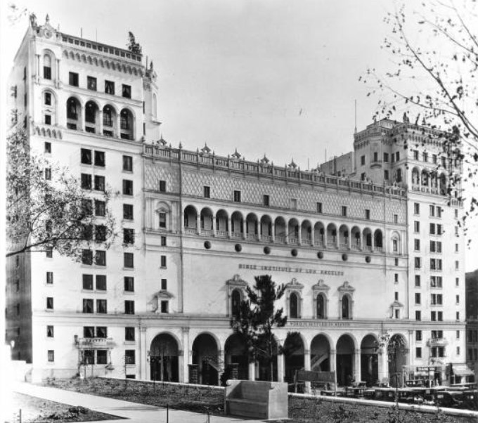
| (1926)^^ - Exterior view of the Bible Institute as seen from the front of the Central Library's South entrance. The light-colored building has two bookend towers and a row of archways across its center. The name of the institute appears over the entryway. |
Historical Notes The Bible Institute building was designed by Walker & Vawter in Renaissance Revival style and had an auditorium that seated 3,500. It was flanked by two thirteen-story dormitories. A large 1935 neon sign which says, "Jesus Saves," sits at the top of the building. The building was constructed in 1915 and demolished in the late 1980s after the church moved to Glendora.* The historic "Jesus Saves" sign from the original building can now be seen atop the Los Angeles University Cathedral. It was relocated there by the late William Eugene Scott, the owner of the building at the time of earthquake, who took it with him when his church relocated following the 1987 Whittier Narrows earthquake.*^ |
 |
|
| (1916)^ - Flower Street looking north between 8th and 9th Street, showing the future site of the Los Angeles Gas and Electric Company building. The First English Lutheran Church is seen on the corner on the left. |
* * * * * |
L.A.'s First Municipal Power Pole
 |
|
| (1916)* - Little could the crowd that assembled at Pasadena Ave (now N. Figueroa St.) and Piedmont Street on March 30, 1916 know that they were seeing the start of the municipal electric distribution system that one day would be the largest city-owned electric utility in the Nation (Click HERE to see more in L.A.'s First Municipal Power Pole). |
Historical Notes In 1910, the City of Los Angeles issued a municipal power bond for preliminary work in connection with electrical power development. City voters approved the project and authorized the $3.5 million bond to finance it. The Bureau of Power and Light (Now DWP) was thus created in 1911 to provide electrical power to the City of Los Angeles. The pole line installed above was used to bring power to LA from the neighboring City of Pasadena. Things would change dramatically after the completion of the LA Aqueduct in 1913. A new hydro power plant (completed in 1917) would now harness the water flowing on the aqueduct and generate more than enough power to meet the demand of a growing city for years to come (Click HERE to see more in First Electricity in Los Angeles). |
Los Angeles Aqueduct
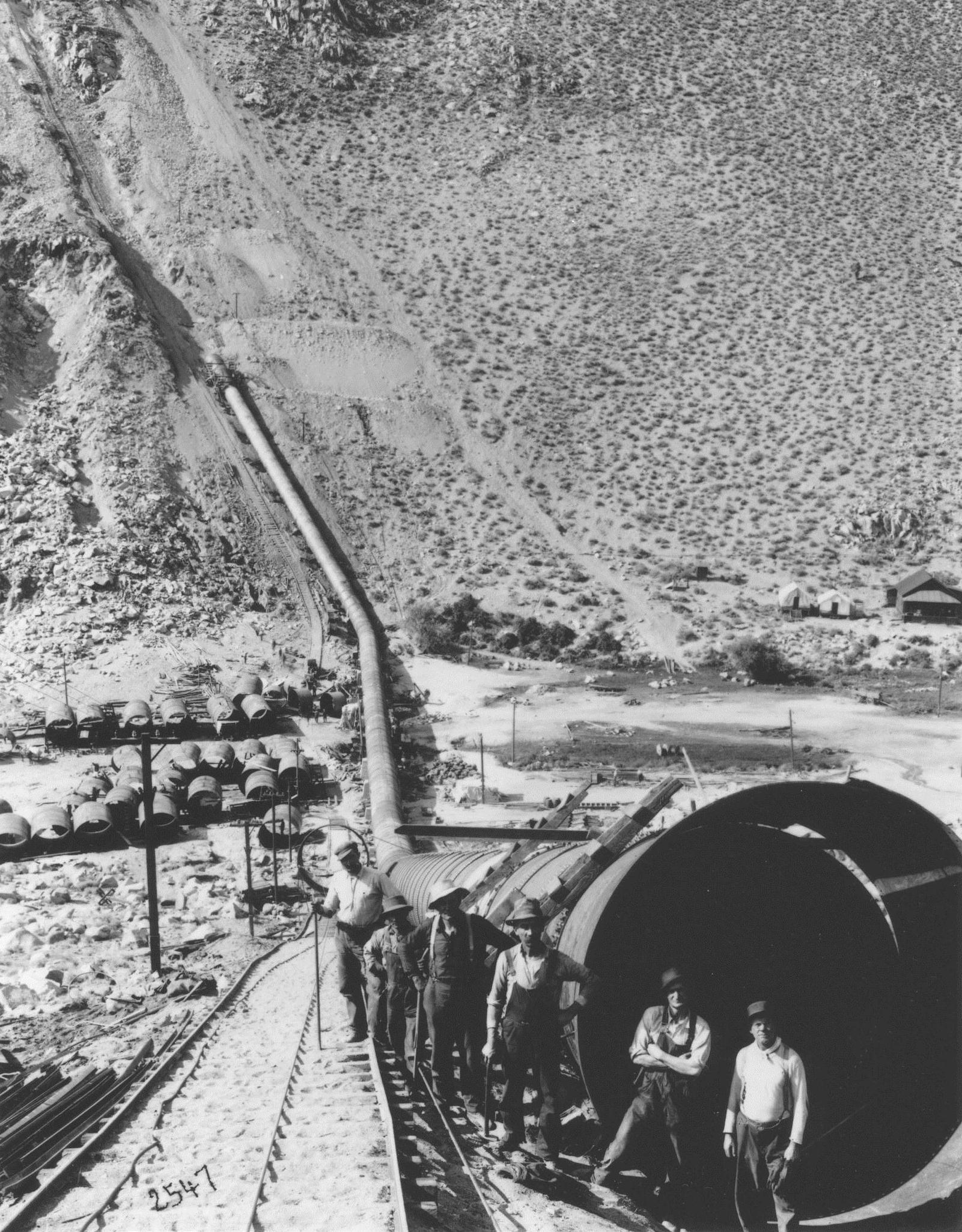 |
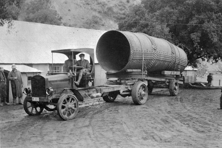
| (ca. 1912)* - A view of workmen posing in front of a new section of the pipeline for the Los Angeles Aqueduct. |
Historical Notes In 1907, Los Angeles voters unanimously approved a $23 million bond issue for the construction of the LA aqueduct. The plan to construct the aqueduct originated with ex LA City Mayor, Frederick Eaton, and LA Water Department Chief, William Mulholland (Click HERE to read more). In 1908, The Bureau of Los Angeles Aqueduct (Click HERE to see DWP Name Change Chronology) began construction of the Los Angeles Aqueduct to bring Owens River water 233-miles south to Los Angeles. The LA Aqueduct was completed in 1913. |
 |
|
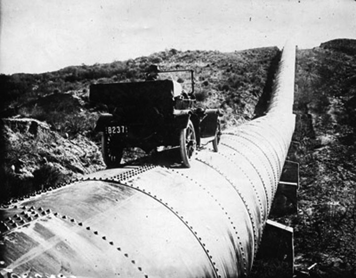
| (ca. 1913)#^#* - A man is seen behind the wheel of an early model car sitting on top of a completed section of the LA Aqueduct. |
Historical Notes The completion of the Los Angeles Aqueduct in 1913 provided surplus water to the city and accelerated the development and growth of the San Fernando Valley. Click HERE to see more in Construction of the L.A. Aqueduct. |
.jpg) |
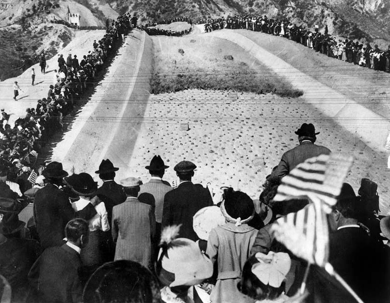
|
| (November 5, 1913)***^ - It is estimated that over 30,000 people attended the opening day ceremonies of the Los Angeles Aqueduct. They came to watch the Owens Valley water cascade into the reservoir. The caption of this picture was that the automobile was "here to stay" in the San Fernando Valley. You can make out some horse and buggies to the rear of the image. |
Historical Notes Over 30,000 Los Angeles residents came to the San Fernando Valley to see the opening ceremony of the Los Angeles Aqueduct, where the first water from the Owens Valley completed its journey to Los Angeles. William Mulholland presided over the ceremony and called out for the water gate to be opened with five of the most famous words in Los Angeles history: ''There it is, take it" |
 |
|
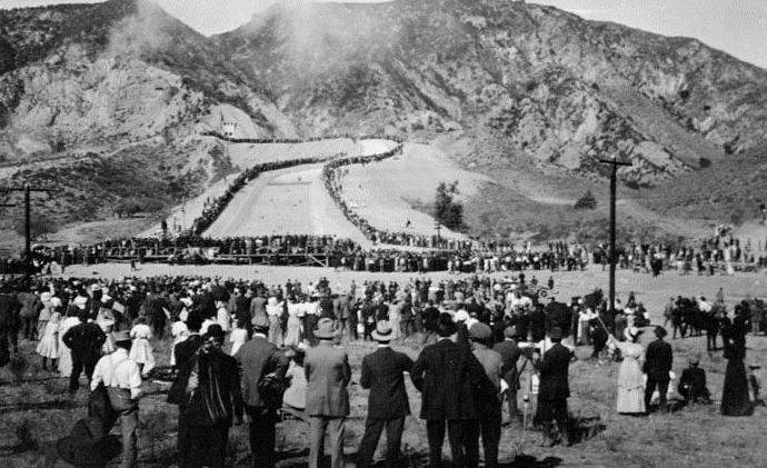
| (1913)*## - Men, women, and children stand in awe as water runs down the cascades at the opening ceremony of the LA Aqueduct. Many of the spectators are waving American flags. The man with the hat rising above the flag on the right is non other than William Mulholland.*^ |
Historical Notes The remarkable photo above was taken from the grandstand a minute and a half after the LA Aqueduct water gates were opened. The view is exactly as the camera caught it, without so much as the touch of a pencil added. The front of the water wall was black from the dust and sediment that had accumulated at the head of the cascade. Click HERE and see more in the Los Angeles Aqueduct Opening Ceremony. |
 |
|
| (November 5, 1913)* - Crowds watch as the water gates are opened and the Los Angeles Aqueduct water starts to flow down into the San Fernando Valley. |
Historical Notes With the completion of the Los Angeles Aqueduct the City had a new source of water. Los Angeles then proceeded to annex the outlying communities attracted by the promise of an abundant water supply. The flurry of annexations began even before the aqueduct was complete. Between 1910 and 1930, the area of Los Angeles increased from 115 sq. miles to 442 sq. miles through annexations of surrounding areas (i.e. Hollywood was annexed in 1910, the San Fernando Valley in 1915). The City's population increased from 533,535 (1915) to 1,300,000 (1930). |
Click HERE to see more in Opening of the LA Aqueduct |
 |
|
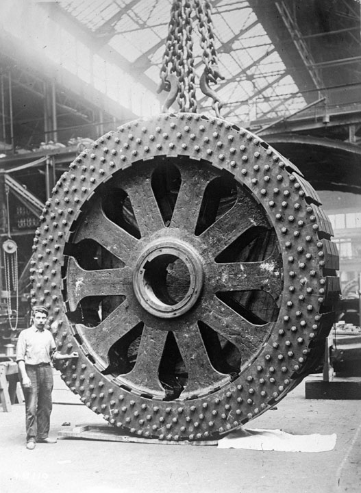
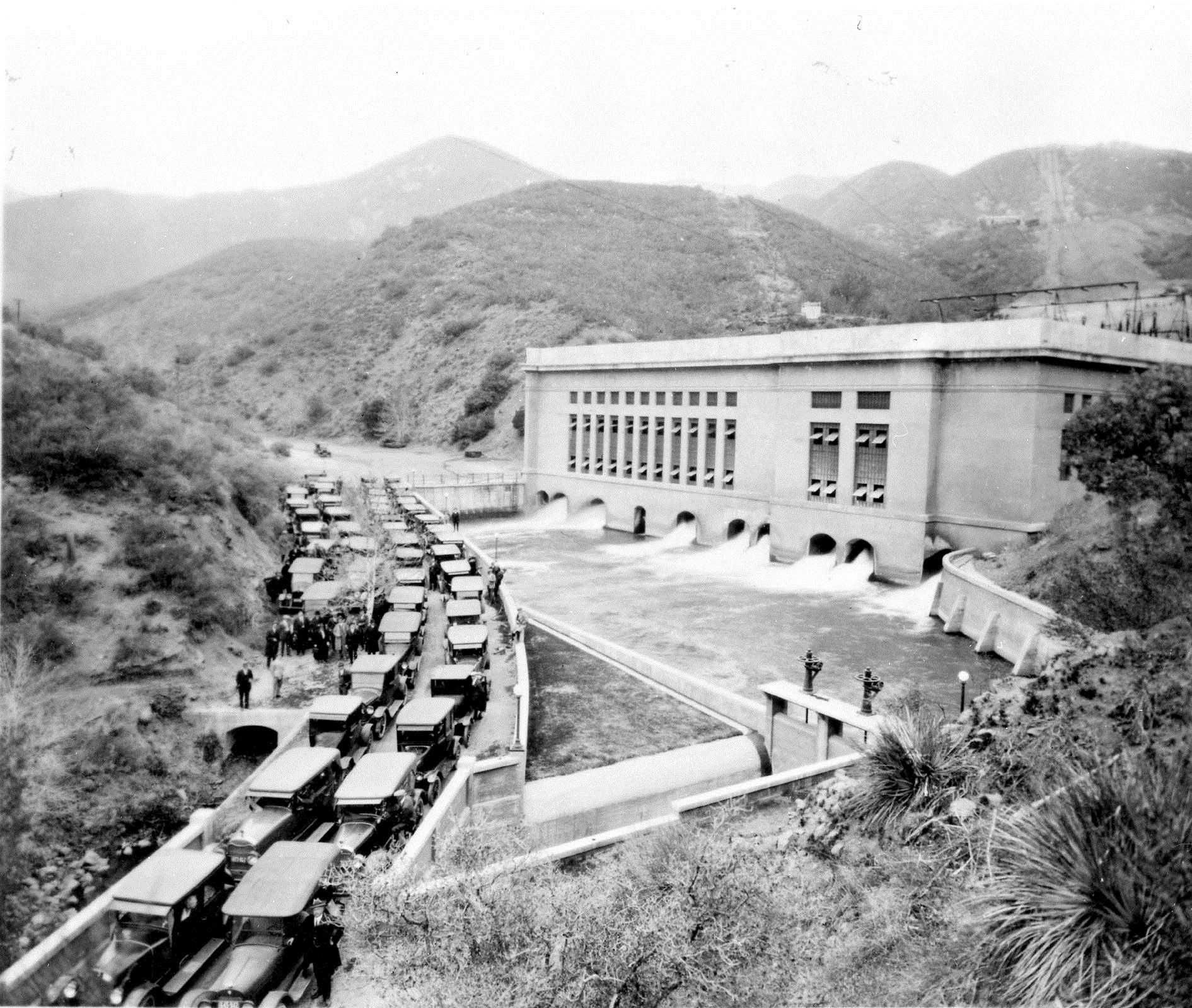
| (ca. 1916)* - What appears to be a gigantic truck wheel is actually the rotor of a new turbine-generator to be installed at Los Angeles's first hydroelectric power plant located in San Francisquito Cyn, 40 miles north of Los Angeles. |
Historical Notes In 1911, the Bureau of Los Angeles Aqueduct Power began construction of the San Francisquito Power Plant No. 1 to generate power from the anticipated water flow of the yet to be completed LA Aqueduct (The LA Aqueduct was completed in 1913). This new source of electric energy coupled with new water via the LA Aqueduct helped spur the growth of Los Angeles and of Southern California. |
 |
|
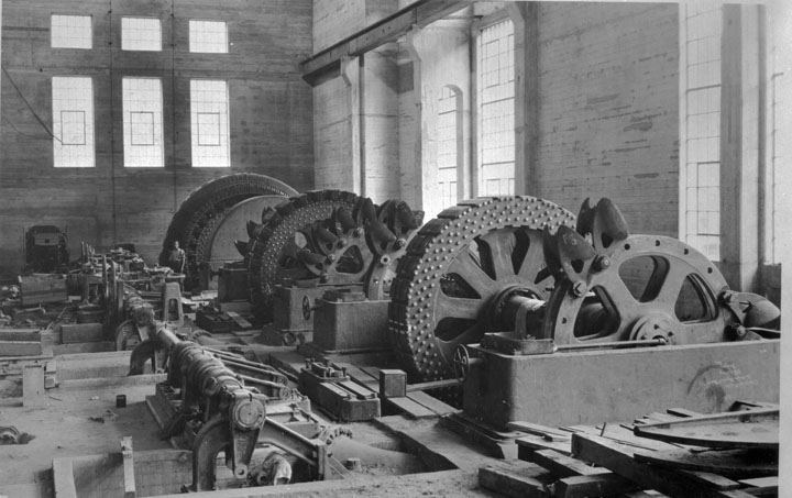
| (ca. 1916)* - Interior view of San Francisquito Power Plant No. 1 during construction and installation of the Pelton wheels. The Pelton wheel was a form of a water wheel connected to the rotor-shaft of a generator. |
Historical Notes The above view shows the internal mechanism of the turbine-generators at San Francisquito Power Plant No. 1. When completed, the new hydro power plant would generate enough electricity to meet the needs of Los Angeles for years to come. |
 |
|
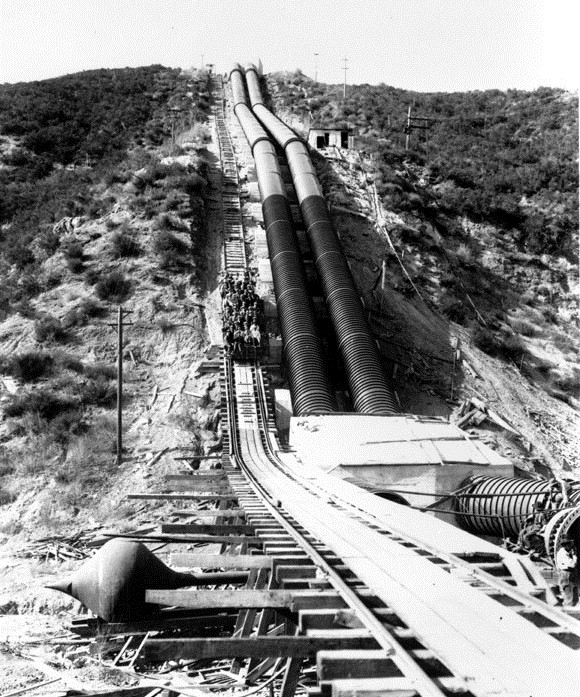
| (ca. 1916)* - View of an early model truck hauling a section of penstock for Power Plant No. 1. |
 |
|
| (ca. 1916)* - View of Power Plant No. 1 construction site where the penstocks are seen being assembled. A rail-car to the left of the penstocks is full of workers carrying them to the top of the incline. |
Historical Notes The water, being tapped from the newly constructed LA Aqueduct, will flow through the two penstocks down 940 feet of head into Power Plant No. 1. |
 |
|
| (1917)* - Opening of the San Francisquito Power Plant No. 1 on March 18, 1917. Construction of the plant began six years earlier in 1911. |
Historical Notes On March 18, 1917 the San Francisquito Power Plant No. 1, Unit 1 was placed in service and energy was delivered to Los Angeles over a newly constructed 115 kV transmission line. The 200 kilowatts generated by Unit 1 were the first commercial kilowatts generated by the Los Angeles Bureau of Power and Light. The LA Bureau of Power and Light now had a source of low cost electricity and more than enough power to meet the City's needs. It would sell its excess San Francisquito generated power to Pasadena over two newly constructed 34 kV lines between the two cities. By 1917, World War I had forced the price of fuel oil to rise making the new lower cost hydroelectric power extremely desirable. |
Click HERE to see more in Electricity on the Aqueduct |
* * * * * |
 |
|
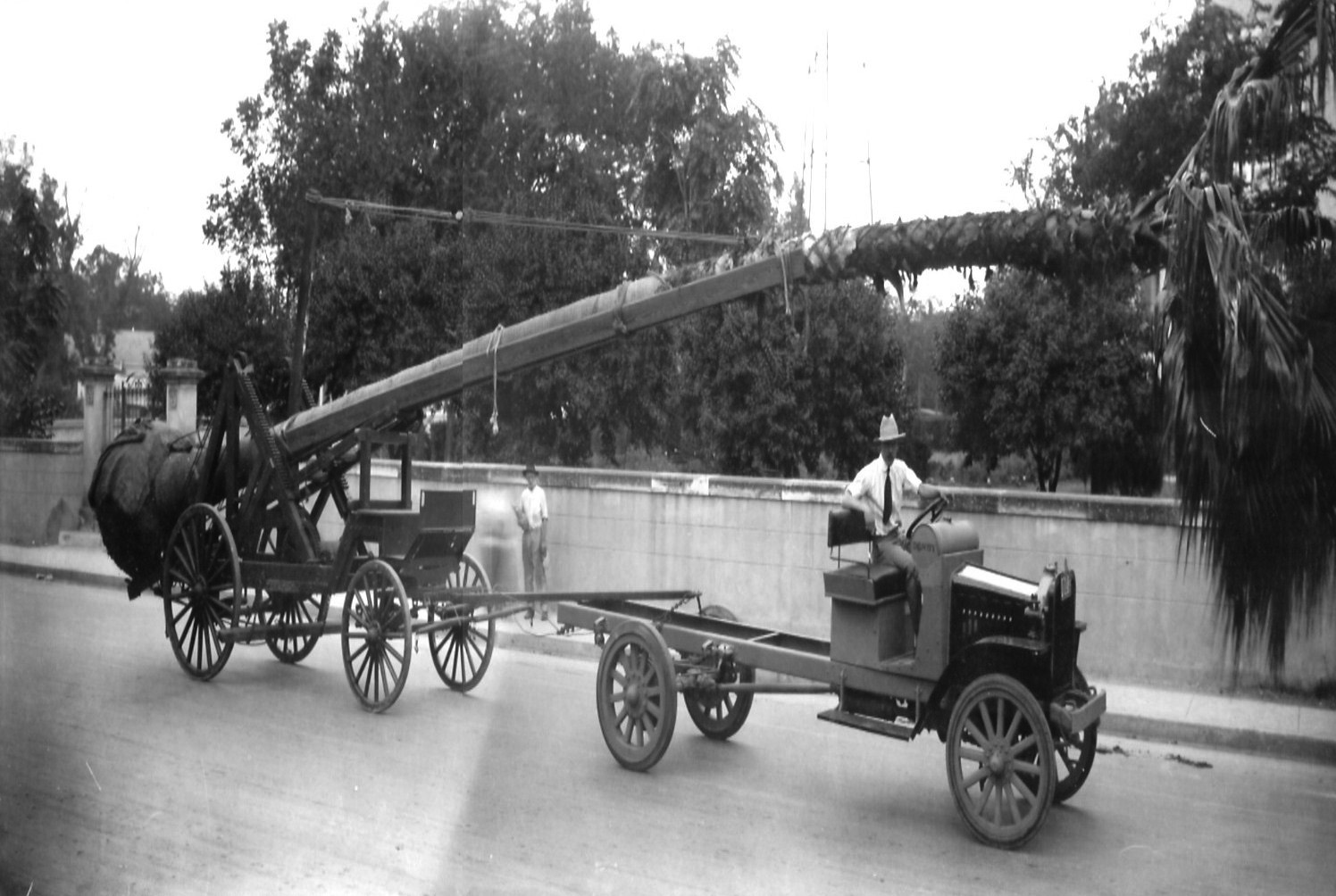
| (ca. 1915)^^** - An early model truck is seen towing a tree-planting rig and also a palm tree. The rig is similar to those once used by the Bureau of Power and Light to install power poles. Click HERE to see more in Early Power Distribution. |
Historical Notes California's eighteenth century Franciscan missionaries were the first to plant palms ornamentally, perhaps in reference to the tree's biblical associations. But it was not until Southern California's turn-of-the-twentieth-century gardening craze that the region's leisure class introduced the palm as the region's preeminent decorative plant. Providing neither shade nor marketable fruit, the palm was entirely ornamental. Palm trees soon appeared throughout Los Angeles, from the front yards of the mansions along Figueroa Street to public spaces like Pershing Square, Eastlake and Westlake Park, and the historic central plaza near Olvera Street.**# |
 |
|
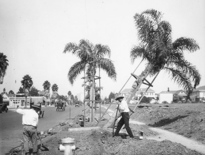
| (ca. 1920s)^ - Workers plant palm trees on Wilshire Boulevard between Western Avenue and Wilton Place. |
Historical Notes Despite the diversity of palms in the Los Angeles area, only one species—Washingtonia filifera, the California fan palm—is native to California. All of L.A.'s other palm species, from the slender Mexican fan palms that line so many L.A. boulevards to the feather-topped Canary Island date palm, have been imported.**# |
* * * * * |
Mt. Lowe Railway
 |
|
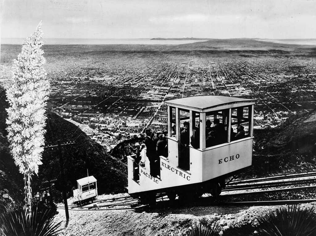
| (ca. 1915)^## - The Echo Mountain incline railway transported Southern Californians into the San Gabriel Mountains. Catalina Island can be seen in the distance. |
Historical Notes At the turn of the century (1893 - 1938) one of the most famous excursion in Southern California was the Mt. Lowe trip. Sightseers from all around the Los Angeles area took a Pasadena car to Altadena and Rubio Canyon. They then transferred to a cable car on the Incline Railway that went up a 62% grade to Echo Mountain. From there they would take a narrow-gauge trolley car winding its way up the rugged San Gabriel Mtns. and finally would arrive at Alpine Tavern on Mt. Lowe, a nearly 7 mile railway ride from the base of the mountain. The views of the valley floor and beyond were spectacular.^ |
 |
|
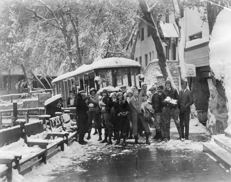
| (1930)^ - Caption on the verso of the image reads, "Redondo High School students arrive at Mt. Lowe Tavern for a snow battle royal." |
Click HERE to see more in Early Views of Mt. Lowe Railway |
* * * * * |
Selig Zoo
 |
|
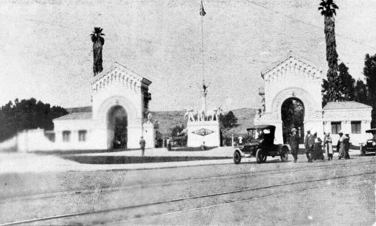
| (ca. 1916)^ - The grand entrance to the privately owned zoo, located at 3800 North Mission Road in Eastlake Park (later Lincoln Park). |
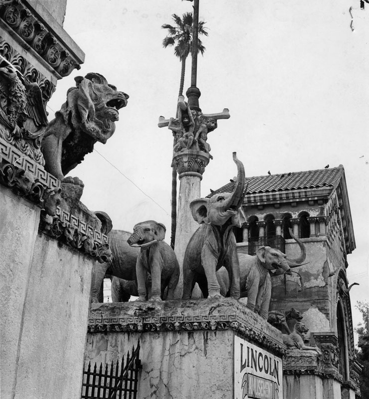
Historical Notes Opened to the public on June 20, 1915, the Selig Zoo, also served as a film production studio for the Selig Polyscope Company, and briefly the Louis B. Mayer Pictures Corporation. Dramatic entrance gates featuring statues of elephants and lions were designed by Italian sculptor Carlo Romanelli, with interior structures by Arthur Burnett Benton.^ |
 |
|
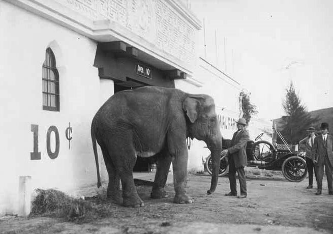
| (ca. 1915)^*# - View of the front entrance to the Selig Zoo. Admission Price: 10 Cents! |
Historical Notes As well as being open to the general public, Selig Zoo provided a habitat for exotic animals used in motion pictures produced by Selig Polyscope Productions. It was headquartered in the old Indian Exposition Building in Lincoln Park, off Mission Road in East Los Angeles. "Selig Place" still intersects Mission Road today. This area later became "Luna Park," a popular amusement area and zoo.^*# Selig Polyscope became insolvent in 1918, and over the years the zoo changed names and ownership. It was known as the Selig Zoo (1915-1925), Luna Park Zoo (1925-1931), L.A. Wild Animal Farms (1931-1932), the California Zoological Gardens (1932-1936), and Zoopark (1936-1940). The zoo officially closed in 1940 and many of the animals were relocated to the Los Angeles Zoo in Griffith Park.^ |
 |
|
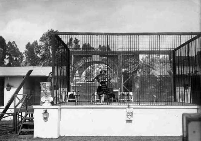
| (ca. 1915)^*# - View of a woman in a cage holding a leopord in her arms at the Selig Zoo and Wild Animal Farm. |
Historical Notes The first Tarzan movie was filmed at the zoo. It was the only zoo south of San Francisco. In time, it became the largest collection of wild animals in the world.^^##^ |
 |
|
| (1962)^ - The once grand entrance to the old privately owned zoo in Lincoln Park shows signs of decay and neglect. Zoo closed following a flood in the early 1930's. |
Historical Notes The Mission Road grounds of the Selig Zoo would subsequently serve as the Lincoln Speedway and the Lincoln Amusement Park, before being redeveloped in the 1950s. The entrance gates would remain standing into the 1960s, before being dismantled and moved to an Inland Empire junkyard.^ |
 |
|
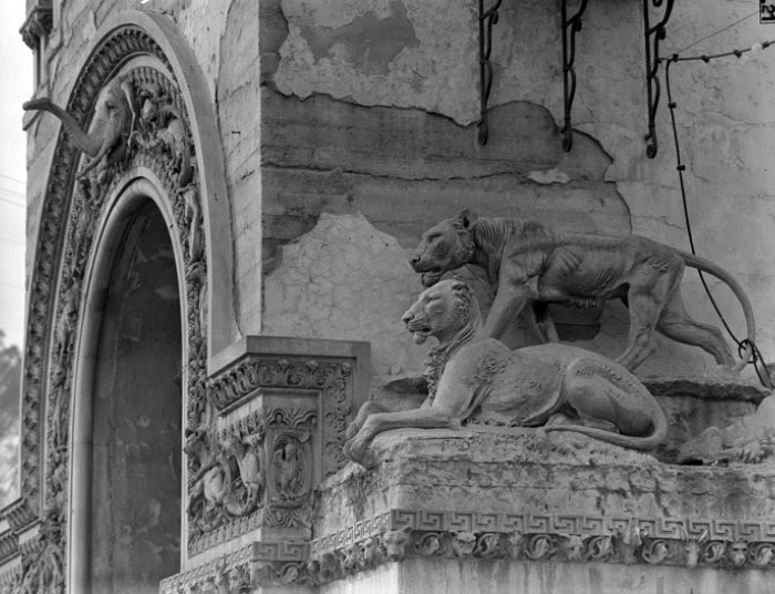
| (1955)^^*# - Close-up view of the entrance gate to the old Selig Zoo showing two lion sculputers. Note the detail design on the arch. |
Historical Notes When the structure was demolished, some of the concrete sculptures disappeared into storage until they resurfaced sometime in 2000. Seven lion sculptures (including these two beauties) were restored and now live in the Los Angeles Zoo. #^ |
Click HERE to see more in Early Views of Southern California Amusement Parks |
* * * * * |
San Fernando Valley
 |
|
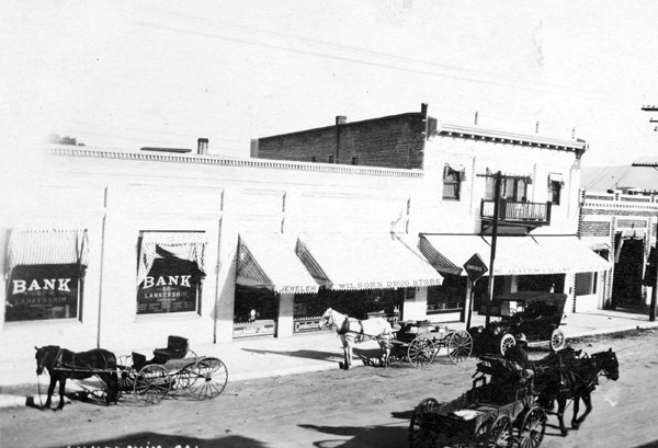
| (1916)***^ - Postcard photograph of a street scene in Lankershim, Calif. outside of the Lankershim Bank. On the street are horse drawn carriages and wagons and an automobile. |
Historical Notes The town of Lankershim (first called Toluca, now North Hollywood) was named after its founding family. Isaac B. Lankershim grew wheat on a wide swath of the Valley floor on his Lankershim Ranch. North Hollywood was established by the Lankershim Ranch Land and Water Company in 1887. It was first named Toluca before being renamed Lankershim in 1896 and finally North Hollywood in 1927.*^ |
 |
|
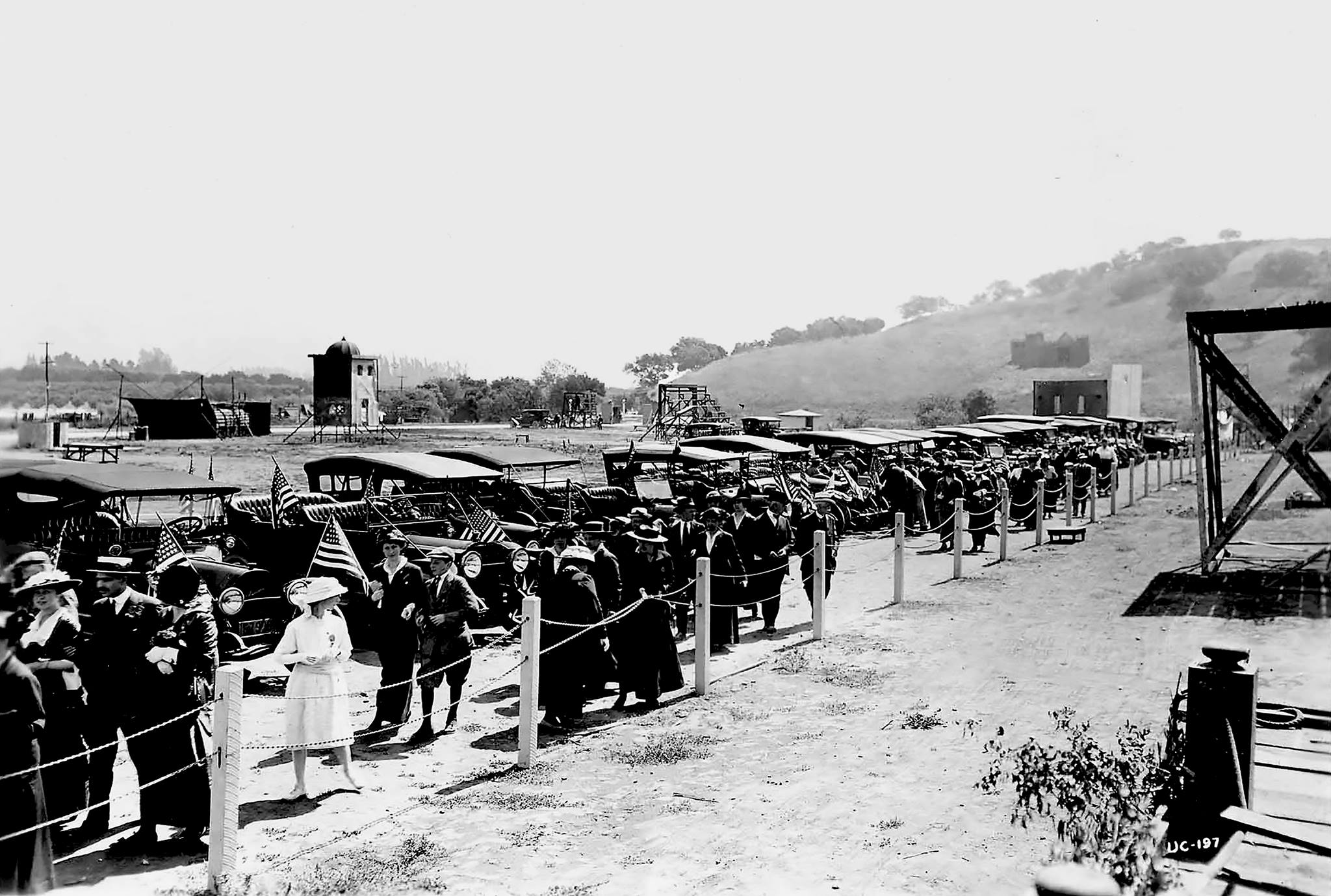
| (1915)#^* - View of the Universal City opening day ceremony, March 15, 1915. |
Historical Notes In 1913, the same year the LA Aqueduct was completed, the Universal Company purchased 12,000 acres of land in the San Fernando Valley near the railroad station of Lankershim and about eight miles from Los Angeles.^*#^ A year earlier, on April 30, 1912, Carl Laemmle merged the Independent Motion Picture Company with five smaller companies to form the Universal Film Manufacturing Company. After visiting his newly acquired west coast operations of Nestor Studios and Nestor Ranch, he renamed the studio "Universal Studios" and the leased Oak Crest Ranch became the first "Universal City" in the San Fernando Valley. The first Universal/Nestor Ranch (Providencia Land and Water Development Company property Oak Crest Ranch) is presently the site of Forest Lawn Memorial Park (Hollywood Hills). In 1915, Universal moved its operations at the Hollywood/Nestor studio and Universal/Nestor Ranch to its new Lankershim Blvd. location before the official opening of Universal City (Lankershim Blvd).*^ |
 |
|
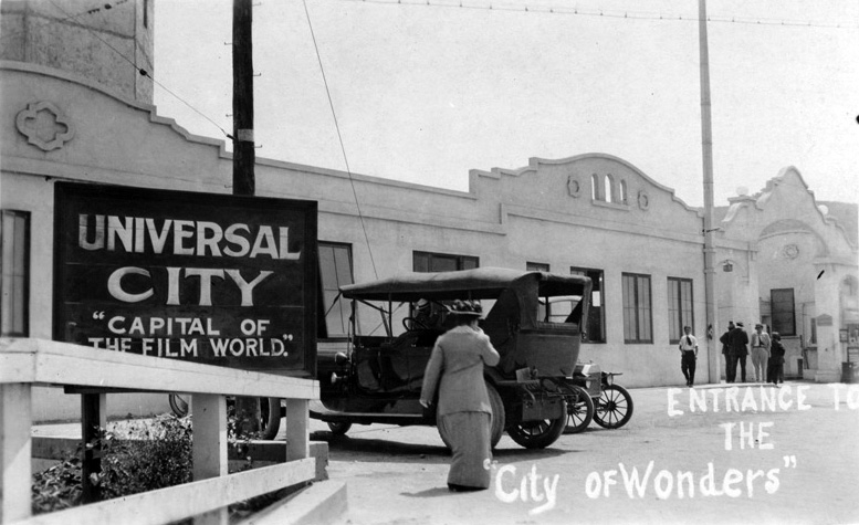
| (ca. 1915)^*# - Postcard view of the entrance to Universal City: "Capital of the Film World" and the "City of Wonders". |
Historical Notes After the gala opening, Carl Laemmle continued to let the general public visit his Movie City - "The City of Wonders." |
 |
|
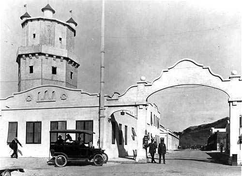
| (ca. 1916)*^^ - View showing the Lankershim Blvd. entrance to Universal Studios. Two security gaurds in uniform stand at watch under the large archway. A tall castle-like tower is seen on the left. Passengers sit in the back of an early model vehicle, possiblly the precursor to today's tram ride. |
Historical Notes Carl Laemmle invited members of the public to watch films being made (in exchange for a 25 cents admission fee). A chicken lunch box was also available for a nickel; the first step towards the Universal Studios theme park we know today.^*#^ |
 |
|
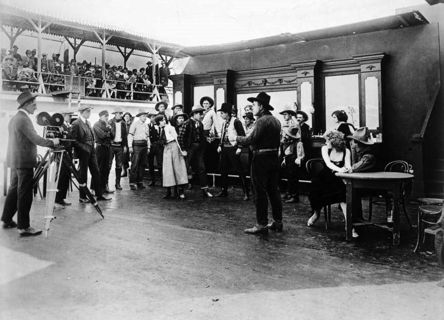
| (ca. 1915)^^ - View showing the filming a western movie on the Front Lot Stage at Universal City. A bar scene can be seen at center, and several men and women are visible in western clothing. A man and a woman are seated at a table in the foreground at right. At left, the director and cameraman can be seen, along with several other assistants. People can be seen sitting on a high balcony at left, in an area labeled "Visitor's Observatory". |
Historical Notes Guests sat in outdoor bleachers and were encouraged to cheer for the heroes and boo the villains! The advent of sound meant the end of the early Universal Studio tour (as the noise the visitors made now disrupted filming) and Universal closed its gates to the general public. Three decades would pass before the studio gates would open again.^*#^ |
Click HERE to see more in Early Views of Southern California Amusement Parks. |
 |
|
| (1918)^^ - Aerial view of the City of San Fernando, 1918. In the foreground is a residential neighborhood composed of small houses on tree-lined streets. At the center of the image is a commercial area composed of mostly two-story square buildings that appear to be shops. One building on the right side of this area has an awning running the length of its façade. In the background are open agricultural fields occasionally bordered by lines of trees. |
Historical Notes The City of San Fernando was named for the nearby Mission San Fernando Rey de España, and was part of the Mexican land grant of Rancho Ex-Mission San Fernando. In 1874 Charles Maclay, San Fernando founder, bought 56,000 acres of the Rancho. In 1882, cousins George K. Porter and Benjamin F. Porter of future Porter Ranch each received one-third of the total land.*^ |
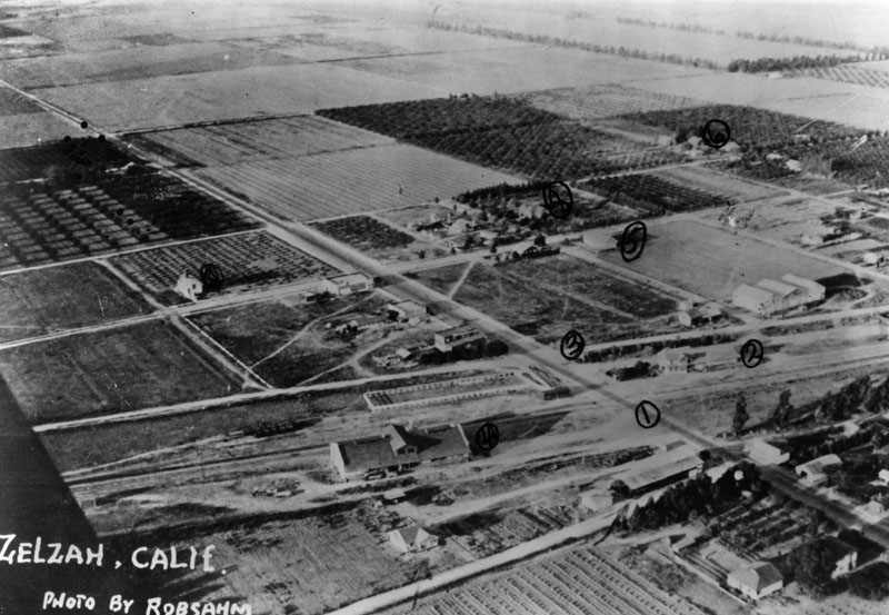 |
|
| (1918)^ - Aerial view of Northridge, then known as Zelzah, in 1918. Number one is Reseda Boulevard, number two is the Southern Pacific Depot, and number three is Parthenia Street. The remaining numbers are not identified. |
Click HERE to see more in Early Views of the San Fernando Valley |
* * * * * |
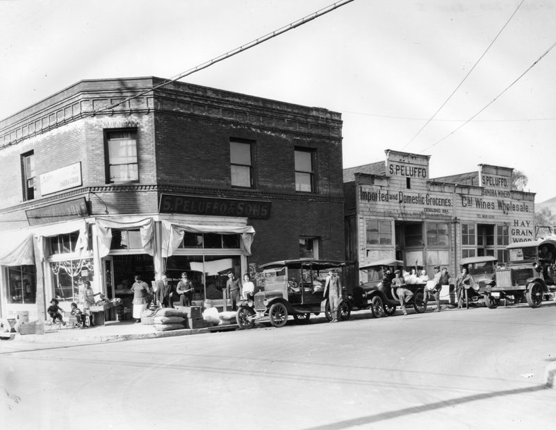 |
|
| (1917)^ - View of the southeast corner of New High and Ord streets, showing the fronts of S. Peluffo's stores, founded in 1894. |
Historical Notes One store is on the ground floor of a two-story, brick building. The other store, a one-story, wooden structure, is next door. The storefront advertises California wines as well as imported and domestic groceries. The store's telephone number is prominently displayed. Early automobiles, one a Peluffo delivery car, and a truck are parked in front and pedestrians, customers and drivers are all posing for the camera. Two children, one on a tricycle and the other in a toy car, are playing while a watchful adult shops. Sacks and cartons of merchandise lie at the curb.^ |
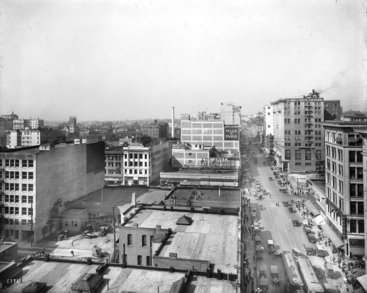 |
|
| (1917)^^ - View looking west on 7th Street towards Hill Street. The empty lot on the northwest corner of 7th and Hill would be occupied by the 9-story Pantages Theatre building (built in 1920). The tall building west of the empty lot is the LA Athletic Club Building (built in 1912). |
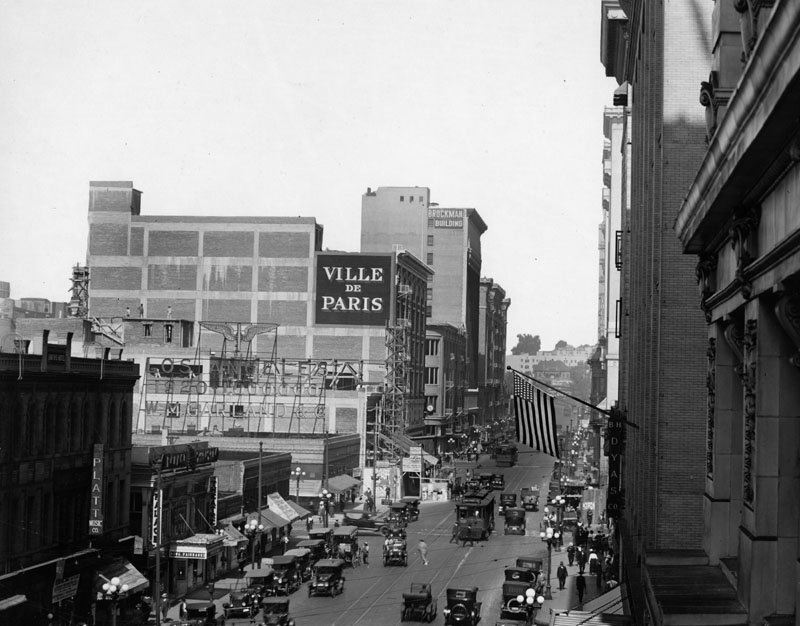 |
|
| (1917)^ - View is looking west on 7th from between Broadway & Hill streets. For decades, 7th Street was a thriving and busy shopping street, traversing all of the major named streets in Downtown. |
Historical Notes Some of the historical buildings pictured in this photograph are, on the left: Smith's Hotel, which was replaced in 1921 by the Loew's State Theatre; Platt Music Co., built in 1927; Ville de Paris Department Store, founded in 1850 in San Francisco by the Verdier brothers, immigrants from France. This store branch was built in 1916 by architects William J. Dodd & William Richards; and at the far left is the John Brockman Building, built in 1911 by Barnett, Haynes & Barnett, it was one of the first reinforced concrete and steel buildings, and with 12 stories, it was also one of the tallest in Los Angeles. And pictured on the right side: B.H. Dyas Co. Department Store with an American flag hanging from the building. This sporting and dry goods store took over the original Ville de Paris Department Store. Looking down at street-level, numerous cars, trolleys, and pedestrians can be seen bustling along.* |
.jpg) |
|
| (ca. 1917)^ – View looking west on 4th Street from Main Street with the Van Nuys Hotel on the northwest corner (right) and Farmers and Merchants Bank on the southwest corner (left). |
Historical Notes Designed in the Classical Revival style, the Farmers and Merchants Bank remains one of Southern California's finest examples of the early "temples of finance" which were popular at the turn of the century. Its two-story facade, reminiscent of a Roman temple, is punctuated by an entrance framed with Corinthian columns topped by a large triangular pediment. Built in 1905, the bank was designed by the firm of Morgan and Walls. The Farmers and Merchants Bank was the first incorporated bank in Los Angeles, founded in 1871 by John G Downey, the seventh governor of California and Isaias W. Hellman, a successful merchant, real estate speculator and banker, and brother of Hermann W. Hellman. Downey was named the first president. Isaias later served as president of the bank till his death in 1920.*^ |
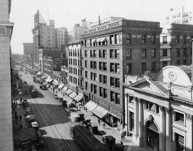 |
|
| (1917)^ - Panoramic view taken from the Westminster Hotel, looking south on Main Street from 4th Street. The Farmers and Merchants Bank with its Greek-like columns stands at lower right. In the distance can be seen the Rosslyn Hotel (NW corner of 5th and Main) with its massive roof-mounted signboard. |
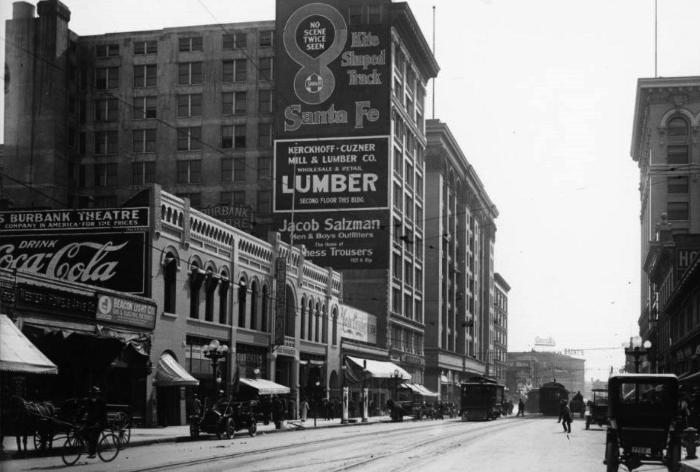 |
|
| (ca. 1918)^^ – View looking south on Main Street toward 6th Street. The beautiful 2-story building on the left is the Burbank Theatre, A horse-drawn wagon can be seen on the left, behind the man on the bicycle. |
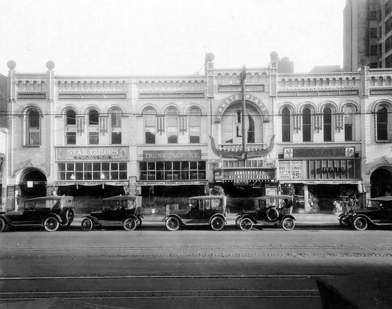 |
|
| (1910s)^ - Five early model cars are seen parked in front of the Burbank Theatre located at 548 S. Main Street. |
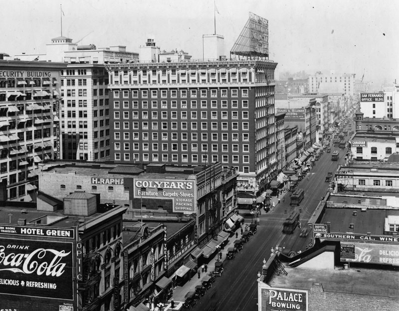 |
|
| (1917)^ - View looking north on Main Street near 6th Street, 1917. The Rosslyn Hotel with the large sign on roof is on the northwest corner of Fifth and Main Streets (451-459 South Main Street). |
Historical Notes In 1913 the Rosslyn Hotel constructed its new building at the northwest corner of 5th and Main Streets, a major expansion of the hotel from its earlier home on Main Street between 4th and 5th Streets. The Hotel Rosslyn has a history unique in all of the city of Los Angeles. Once the tallest building in LA, the 12-story Rosslyn boasted in it's large rooftop sign as being the "Fireproof Million Dollar Hotel." At that time, the area around Main Street was truly the center of Los Angeles. Through the teens and twenties, the financial, commercial, and entertainment center of Southern California was based in Downtown Los Angeles, and the Rosslyn Hotel was one of its premier destinations.**^^ |
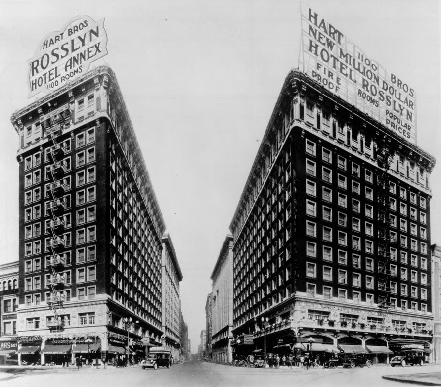 |
|
| (1924)^ - Hotel Rosslyn and Hart Brothers Rosslyn Hotel Annex, located on the west corners of 5th and Main streets. |
Historical Notes In 1923, as a result of the prosperity enjoyed by the Rosslyn and the surrounding district, the Rosslyn Annex was built across 5th Street, and today is still called the Rosslyn Hotel. The two buildings were connected by an underground marble tunnel, portions of which survive to this day. Both buildings were designed by architect John Parkinson, who was one of the most prolific architects in Downtown Los Angeles, responsible for much of the area's finest architecture, including Union Station, Bullock's Wilshire, the Title Guarantee Building, the Continental Building, the Alexandria Hotel, the Los Angeles Athletic Club, Security Bank (now the Los Angeles Theatre Center), the Los Angeles Memorial Coliseum, and Los Angeles City Hall.**^^ |
* * * * * |
Please Support Our CauseWater and Power Associates, Inc. is a non-profit, public service organization dedicated to preserving historical records and photos. We are of the belief that this information should be made available to everyone—for free, without restriction, without limitation and without advertisements. Your generosity allows us to continue to disseminate knowledge of the rich and diverse multicultural history of the greater Los Angeles area; to serve as a resource of historical information; and to assist in the preservation of the city's historic records.
|
For more Historical Los Angeles Views click one of the following:
For Other Historical Views click one of the following:
See Our Newest Sections:
To see how Water and Electricity shaped the history of Los Angeles click one of the following:
Water:
Power:
* * * * * |
References and Credits
* DWP - LA Public Library Image Archive
^ LA Public Library Image Archive
^*The Valley Observed: Street Name Origins; Timeline of Valley History
*# blogdowntown: Third Street Tunnel
#* About.Com: History of Electric Vehicles
#^*San Fernando Valley Relics - valleyrelics.com: Universal Studios Tour Opening Day
#**California Historical Society Digital Archive
#*^Library of Congress: Panoramic view over Central Park, ca. 1911
*##LA Times: Dig Into History You'll Find Snake Oil..Victor Girard Kleinberger ; Building the LA Aqueduct
^##Metropolitan Transportation Library and Archive
*#*Historical Los Angeles Theatres: The Philharmonic Auditorium; Downtown Theatres
*^#LincolnHeightsLA.com: Legion Ascot Speedway
^*#California State Library Image Archive
+^^Facebook: Garden of Allah Novels
*#^History of Hermosa Beach - Maureen Megowan
^#*City of Redondo Beach HIstory
^^*Early Downtown Los Angeles - Cory Stargel, Sarah Stargel; Hollenbeck Hotel
***Los Angeles Historic - Cultural Monuments Listing
**^Historicechopark.org: Echo Park Lake
*^*California Historical Landmarks Listing (Los Angeles)
*^^Nuestra Señora la Reina de los Ángeles: losangelespast.com
+^^ComptonCity.org: History of the City of Compton
^^^Aerofiles - US Aviation Firsts
**^^History of the Rosslyn Hotel
***^Oviatt Library Digital Archives
**^*Historical LA Theatres: The Philharmonic Auditorium
****Windward Avenue - virtualvenice.info
*##*Chatsworth Historical Society
*^#^Huntington Digital Library Archive
^*#^Studiotour.com
**#^LA Magazine: How Ivanhoe Canyon Became Silver Lake
*#*^HistoryLosAngeles.blogspot.com: Lankershim Hotel
^*##Calisphere: University of California Image Archive
^^*#UCLA Library Digital Archive
^^#^Faceebook.com - Great Photos from Los Angeles' Past: 1903 Sunset Blvd.
^#*^Facebook.com - Bizarre Los Angeles
^^^#Los Angeles Fire Department Historical Archive
^^**Gary Kennemer Collection: Palm Tree Truck
^#**Facebook.com - City of Angels: Alligator Farm; Lankershim Hotel
*^^*Vintage Los Angeles - Facebook.com: Bliss Station; Broadway and 1st Postcard
#*#*UC Riverside Image Archive
#^#^Zotzelectrical.com: Baker Motors
##^^City of Angels: 1910s - Facebook.com
##++Facebook.com - Beverly Hills Heritage
#^*#Urban Diachrony - Occidental Hotel; Intersection of 3rd and Spring Streets
#^^*Oceanpark.wordpress.com: Ocean Park Time Line
#^**Ocean Park History: oceanpark.wordpress.com
#^*^Pinterest.com: Old Hollywood
#*^*Santa Monica Beach Stories
#^#*A History of the San Fernnando Valley: lahistoryarchive.org
#+++Yahoo.com: Beverly Hills Hotel
#^*^#Laurel Canyon Association
***^^Will Rogers Memorial Park
**^*^Pacific Electric Historical Society
^***^Ow.ly: Lake and 12th - Before and After
^^*^^La Brea Tar Pits - Need Supply Co.
^^^^*Bureau of Street Lighting Image Archive
*^^^*LA Bureau of Street Services: bss.lacity.org
^^^*San Fernando Valley Relics: Facebook.com
^^##^LincolnHeightsLa.com: Selig Zoo
**# KCET - Lost Tunnels of Downtown LA; Three Forgotton Incline Railways; A Brief History of LA Bridges; A Brief History of Palm Trees; LA Flood of 1938: Cement the River's Future; Griffith Park
^#^Noirish Los Angeles - forum.skyscraperpage.com; Windsor-Wilshire Streetlight; Sixth and Spring Streets (CHS); Fire Station Horses and Dogs; 1907/1909 LA Panoramic; 1910 Broadway; Lookout Mtn. View; Steamroller; LA Times Building Bombing
*^ Wikipedia: H.J. Whitley; Occidental College; Beverly Hills; Beverly Hills Hotel; Los Angeles Railway; Pershing Square; Broadway Tunnel: Isaac Van Nuys; Sawtelle; Port of Los Angeles; Tournament of Roses Parade; Angels Flight; Occidental College; Mt. Washington, LA; Broadway, LA; Hancock Park; La Brea Tar Pits; Los Angeles City Oil Field; Deadman's Island (San Pedro); Moses Sherman; Rose Bowl Game; Hollywood Hotel; Hollywood HIgh School; California Club; San Pedro; Salt Lake Oil Field - Gilmore Oil Field; Westwood; 2nd Street Tunnel; Hermosa Beach; Los Angeles Memorial Coliseum; Redondo Beach Pier; Redondo Beach; West Hollywood; Pacific Palisades; 1910 L.A. International Air Meet at Dominguez Hills; Hancock Park; Marlborough School; Farmers and Merchants Bank; North Hollywood; Sunset Boulevard; Coldwater Canyon; Compton; North Hollywood; City of San Fernando; History of Los Angeles Population Growth; Selig Polyscope Company; Nelson Story; Los Angeles Philharmonic; International Savings & Exchange Bank Building; Engine House No. 18; Los Angeles Alligator Farm; James Boon Lankershim; Universal City; Church of the Open Door; MacArthur Park; History of the San Fernando Valley; Fremont Hotel; Lafayette Park; Laurel Canyon; Lincoln Park (Eastlake Park)
< Back